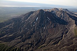
Stratovolcano in eastern Kamchatka, Russia
| Kikhpinych | |
|---|---|
 | |
| Highest point | |
| Elevation | 1,515 m (4,970 ft) |
| Coordinates | 54°29′13″N 160°15′11″E / 54.487°N 160.253°E / 54.487; 160.253 |
| Geography | |
 | |
| Location | Kamchatka, Russia |
| Parent range | Eastern Range |
| Geology | |
| Mountain type | Stratovolcanoes |
| Last eruption | 1550 |
Kikhpinych (Russian: Кихпиныч) is a stratovolcano located in the eastern part of the Kamchatka Peninsula, which feeds the famous Valley of Geysers.
At its foot is a 2-by-0.5-km (1.2-by-0.3-mi) area known as the "Valley of Death", where volcanic gases accumulate and kill birds and mammals that enter the valley. Research in the 1970s and 1980s showed that a mix of hydrogen sulphide, carbon dioxide, sulphur dioxide, and carbon disulphide was produced by the volcano, gathering in a valley area where it could not be easily dispersed by winds, creating a predator trap. The gas forms in spring when the snow melts, first killing birds which drink at the river, followed by foxes and other carnivores which are attracted to the carrion.
See also
References
- "Kikhpinych". Global Volcanism Program. Smithsonian Institution.
- Egorov, Boris (8 February 2018). "How to visit Russia's Valley of Death and survive". www.rbth.com. Retrieved 1 September 2020.
This Kamchatka Krai location article is a stub. You can help Misplaced Pages by expanding it. |