Statutory Town in Colorado, United States
| Kit Carson, Colorado | |
|---|---|
| Statutory Town | |
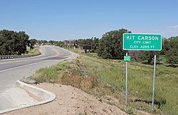
 Kit Carson (2013) Kit Carson (2013) | |
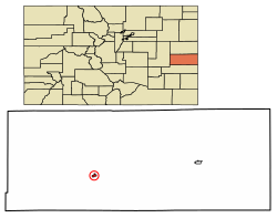
 Location within Cheyenne County and Colorado Location within Cheyenne County and Colorado | |
| Coordinates: 38°45′50″N 102°47′38″W / 38.76389°N 102.79389°W / 38.76389; -102.79389 | |
| Country | United States |
| State | Colorado |
| County | Cheyenne |
| Incorporated | July 13, 1931 |
| Area | |
| • Total | 0.58 sq mi (1.51 km) |
| • Land | 0.58 sq mi (1.51 km) |
| • Water | 0.00 sq mi (0.00 km) |
| Elevation | 4,285 ft (1,306 m) |
| Population | |
| • Total | 255 |
| • Density | 440/sq mi (170/km) |
| Time zone | UTC−7 (MST) |
| • Summer (DST) | UTC−6 (MDT) |
| ZIP Code | 80825 |
| Area code | 719 |
| FIPS code | 08-41010 |
| GNIS ID | 195254 |
| Website | townofkitcarson.com |
Kit Carson is a statutory town in Cheyenne County, Colorado, United States. The population was 255 at the 2020 United States Census.
History
The town was named in honor of frontiersman Christopher Houston "Kit" Carson.
Geography
Kit Carson is located at 38°45′50″N 102°47′38″W / 38.76389°N 102.79389°W / 38.76389; -102.79389 (38.763999, -102.793843).
According to the United States Census Bureau, the town has a total area of 0.6 square miles (1.6 km), all land.
Climate
| Climate data for Kit Carson, Colorado (1991–2020 normals, extremes 1939–present) | |||||||||||||
|---|---|---|---|---|---|---|---|---|---|---|---|---|---|
| Month | Jan | Feb | Mar | Apr | May | Jun | Jul | Aug | Sep | Oct | Nov | Dec | Year |
| Record high °F (°C) | 77 (25) |
83 (28) |
87 (31) |
94 (34) |
106 (41) |
109 (43) |
108 (42) |
106 (41) |
102 (39) |
96 (36) |
85 (29) |
79 (26) |
109 (43) |
| Mean daily maximum °F (°C) | 45.4 (7.4) |
47.8 (8.8) |
57.7 (14.3) |
65.9 (18.8) |
75.3 (24.1) |
86.7 (30.4) |
92.2 (33.4) |
89.2 (31.8) |
82.3 (27.9) |
68.8 (20.4) |
55.3 (12.9) |
45.4 (7.4) |
67.7 (19.8) |
| Daily mean °F (°C) | 28.6 (−1.9) |
31.1 (−0.5) |
40.6 (4.8) |
48.8 (9.3) |
59.2 (15.1) |
70.2 (21.2) |
75.7 (24.3) |
73.3 (22.9) |
64.8 (18.2) |
50.9 (10.5) |
38.2 (3.4) |
29.2 (−1.6) |
50.9 (10.5) |
| Mean daily minimum °F (°C) | 11.7 (−11.3) |
14.4 (−9.8) |
23.5 (−4.7) |
31.7 (−0.2) |
43.2 (6.2) |
53.8 (12.1) |
59.2 (15.1) |
57.5 (14.2) |
47.3 (8.5) |
33.0 (0.6) |
21.0 (−6.1) |
12.9 (−10.6) |
34.1 (1.2) |
| Record low °F (°C) | −32 (−36) |
−29 (−34) |
−24 (−31) |
5 (−15) |
19 (−7) |
31 (−1) |
37 (3) |
36 (2) |
17 (−8) |
7 (−14) |
−17 (−27) |
−29 (−34) |
−32 (−36) |
| Average precipitation inches (mm) | 0.26 (6.6) |
0.35 (8.9) |
0.65 (17) |
1.32 (34) |
2.24 (57) |
2.25 (57) |
2.65 (67) |
2.71 (69) |
0.90 (23) |
1.25 (32) |
0.42 (11) |
0.42 (11) |
15.42 (392) |
| Average snowfall inches (cm) | 2.4 (6.1) |
3.0 (7.6) |
3.0 (7.6) |
0.9 (2.3) |
0.0 (0.0) |
0.0 (0.0) |
0.0 (0.0) |
0.0 (0.0) |
0.0 (0.0) |
0.2 (0.51) |
2.4 (6.1) |
4.0 (10) |
15.9 (40) |
| Average precipitation days (≥ 0.01 in) | 1.7 | 2.5 | 3.3 | 4.5 | 6.4 | 5.8 | 7.3 | 6.5 | 3.2 | 3.0 | 2.2 | 2.1 | 48.5 |
| Average snowy days (≥ 0.1 in) | 1.1 | 1.5 | 1.5 | 0.8 | 0.0 | 0.0 | 0.0 | 0.0 | 0.0 | 0.1 | 1.2 | 2.0 | 8.2 |
| Source: NOAA | |||||||||||||
Demographics
| Census | Pop. | Note | %± |
|---|---|---|---|
| 1940 | 333 | — | |
| 1950 | 379 | 13.8% | |
| 1960 | 356 | −6.1% | |
| 1970 | 220 | −38.2% | |
| 1980 | 278 | 26.4% | |
| 1990 | 305 | 9.7% | |
| 2000 | 253 | −17.0% | |
| 2010 | 233 | −7.9% | |
| 2020 | 255 | 9.4% | |
| U.S. Decennial Census | |||
See also
References
- "Active Colorado Municipalities". State of Colorado, Department of Local Affairs. Archived from the original on December 12, 2009. Retrieved September 1, 2007.
- ^ "Kit Carson, Colorado", Geographic Names Information System, United States Geological Survey, United States Department of the Interior
- "Colorado Municipal Incorporations". State of Colorado, Department of Personnel & Administration, Colorado State Archives. December 1, 2004. Retrieved September 2, 2007.
- "2019 U.S. Gazetteer Files". United States Census Bureau. Retrieved July 1, 2020.
- ^ United States Census Bureau. "Kit Carson town; Colorado". Retrieved April 28, 2023.
- "ZIP Code Lookup". United States Postal Service. Archived from the original (JavaScript/HTML) on November 4, 2010. Retrieved October 21, 2007.
- Gannett, Henry (1905). The Origin of Certain Place Names in the United States. Govt. Print. Off. pp. 176.
- "US Gazetteer files: 2010, 2000, and 1990". United States Census Bureau. February 12, 2011. Retrieved April 23, 2011.
- "NOWData - NOAA Online Weather Data". National Oceanic and Atmospheric Administration. Retrieved April 6, 2024.
- "Summary of Monthly Normals 1991-2020". National Oceanic and Atmospheric Administration. Retrieved April 6, 2024.
External links
| Municipalities and communities of Cheyenne County, Colorado, United States | ||
|---|---|---|
| County seat: Cheyenne Wells | ||
| Towns |  | |
| CDP | ||
| Other unincorporated communities | ||