Town in North Rhine-Westphalia, Germany
| Lohmar | |
|---|---|
| Town | |
 Protestant church in Honrath Protestant church in Honrath | |
 Coat of arms Coat of arms | |
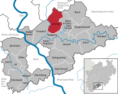
Location of Lohmar within Rhein-Sieg-Kreis district
 | |
  | |
| Coordinates: 50°49′N 7°13′E / 50.817°N 7.217°E / 50.817; 7.217 | |
| Country | Germany |
| State | North Rhine-Westphalia |
| Admin. region | Köln |
| District | Rhein-Sieg-Kreis |
| Subdivisions | 12 |
| Government | |
| • Mayor (2020–25) | Claudia Wieja (Greens) |
| Area | |
| • Total | 65.5 km (25.3 sq mi) |
| Elevation | 64 m (210 ft) |
| Population | |
| • Total | 30,894 |
| • Density | 470/km (1,200/sq mi) |
| Time zone | UTC+01:00 (CET) |
| • Summer (DST) | UTC+02:00 (CEST) |
| Postal codes | 53797 |
| Dialling codes | 02205, 02206, 02241, 02246, 02247 |
| Vehicle registration | SU |
| Website | www.lohmar.de |
Lohmar (Ripuarian: Luhme) is a municipality and a town in the Rhein-Sieg district, in North Rhine-Westphalia, Germany.
Geography
Lohmar is located about 20 km east of Cologne and 15 km north-east of Bonn in the Bergisches Land area. Because it is only 20 minutes by car to Cologne or Bonn, Lohmar is a popular place for commuters.
The municipality of Lohmar is divided into two parts: Lohmar itself and Wahlscheid 7 km to the north. About a third of the total population lives in Wahlscheid (a separate municipality until 1969). In total Lohmar comprises 30 districts. The most important are Lohmar itself (est. population approx. 9500), Donrath (2200), Heide (2100) and Birk (1400) in the south, as well as Wahlscheid (3200), Neuhonrath (2000), Honrath (1500) and Agger (1000) in the north.
Lohmar, Donrath, Wahlscheid, Neuhonrath and Agger are located in the Agger valley, the other villages in the uplands.
History
Lohmar was first mentioned as a donation of archbishop Sigewid to the church of Cologne. A farmyard in Lomereis mentioned.
Lohmar is also mentioned on the Arc de Triomphe in Paris as a place of Napoleon's visit. While his inspection of the army positioned in the Rhineland in 1811 he lived in Schloss Auel in Lohmar.
Politics
Town council
| This section needs to be updated. Please help update this article to reflect recent events or newly available information. (June 2021) |
The town council consists of 40 members. The current breakdown after the local elections held on 13 September 2020 is as follows:
The CDU and Grünen govern the town as a coalition.
Mayor
- Mayor: Claudia Wieja (Grüne)
Coat of arms

The coat of arms contains a lion of Berg in the upper fragment. It symbolizes the former jurisdiction by the Earldom of Berg. The lower fraction shows the meeting of the Agger and the Sülz rivers.
Twin towns – sister cities
See also: List of twin towns and sister cities in GermanyLohmar is twinned with:
 Eppendorf, Germany (1990)
 Frouard, France (1974)
 Pompey, France (1974)
 Vila Verde, Portugal (1986)
 Żarów, Poland (2007)
Transport
Lohmar is served by Honrath railway station on the Cologne–Overath railway. A train to Cologne stops every 30 minutes. The trip to Cologne lasts about 30 minutes. A service runs in the other direction to Overath every 30 minutes.
Roads
Lohmar is connected to the Bundesautobahn 3 with following exits:
- Rösrath/Lohmar-Nord (only coming from Cologne)
- Lohmar-Nord/Rösrath
- Lohmar
The Bundesautobahn 4 connects through exit
- Overath
Airports
The Cologne Bonn Airport is reachable within 25 minutes.
References
- Wahlergebnisse in NRW Kommunalwahlen 2020, Land Nordrhein-Westfalen, accessed 29 June 2021.
- "Bevölkerung der Gemeinden Nordrhein-Westfalens am 31. Dezember 2023 – Fortschreibung des Bevölkerungsstandes auf Basis des Zensus vom 9. Mai 2011" (in German). Landesbetrieb Information und Technik NRW. Retrieved 20 June 2024.
- "Städtepartnerschaften". lohmar.de (in German). Lohmar. Retrieved 21 January 2021.
External links
- Official website (in German)
| Towns and municipalities in Rhein-Sieg-Kreis | ||
|---|---|---|