| Kupa | |
|---|---|
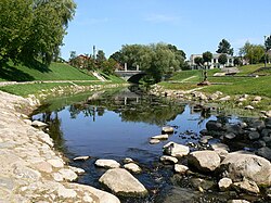
 Kupa at Kupiškis Kupa at Kupiškis | |
| Location | |
| Country | Lithuania |
| Physical characteristics | |
| Source | |
| • location | 5 km (3.1 mi) northeast from Šimonys |
| Mouth | Lėvuo |
| • coordinates | 55°50′07″N 24°56′38″E / 55.8354°N 24.944°E / 55.8354; 24.944 |
| Length | 27 km (17 mi) |
| Basin size | 188 km (73 sq mi) |
| Discharge | |
| • average | 1 m/s (35 cu ft/s) |
| Basin features | |
| Progression | Lėvuo→ Mūša→ Lielupe→ Baltic Sea |
The Kupa is a small river in northern Lithuania and a left tributary of the Lėvuo. At first it flows to north but then near Juodupė town turns to the west. It flows through Kupiškis; the name of the town is derived from name of the river.
References
- LIETUVOS RESPUBLIKOS UPIŲ IR TVENKINIŲ KLASIFIKATORIUS (Republic of Lithuania- River and Pond Classifications). Ministry of Environment (Lithuania). Accessed 2020-01-31.
This article related to a river in Lithuania is a stub. You can help Misplaced Pages by expanding it. |