| Láhpoluoppal | |
|---|---|
| Village | |
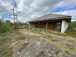
 Lappoluobbal church Lappoluobbal church | |
  | |
| Coordinates: 69°12′31″N 23°45′36″E / 69.20861°N 23.76000°E / 69.20861; 23.76000 | |
| Country | Norway |
| Region | Northern Norway |
| County | Finnmark |
| District | Vest-Finnmark |
| Municipality | Kautokeino |
| Elevation | 329 m (1,079 ft) |
| Time zone | UTC+01:00 (CET) |
| • Summer (DST) | UTC+02:00 (CEST) |
| Post Code | 9520 Kautokeino |
Láhpoluoppal is a village in Kautokeino Municipality in Finnmark county, Norway. The village is located at the southern end of the large lake Láhpojávri, along the Norwegian National Road 92. The small village lies on the vast Finnmarksvidda plateau, about half-way between the villages of Masi and Kautokeino. The Láhpoluoppal Chapel is located in the village.
References
- "Láhpoluoppal" (in Norwegian). yr.no. Retrieved 2013-04-01.
This article about a location in Finnmark is a stub. You can help Misplaced Pages by expanding it. |