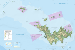
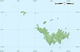
 Map of Saint Barthélemy and islands. Map of Saint Barthélemy and islands. | |||||||||||||||||||
   | |||||||||||||||||||
| Geography | |||||||||||||||||||
|---|---|---|---|---|---|---|---|---|---|---|---|---|---|---|---|---|---|---|---|
| Location | Caribbean | ||||||||||||||||||
| Coordinates | 17°55′11″N 62°47′53″W / 17.91972°N 62.79806°W / 17.91972; -62.79806 | ||||||||||||||||||
| Archipelago | Leeward Islands, Lesser Antilles | ||||||||||||||||||
| Adjacent to | Saint Barthélemy Channel | ||||||||||||||||||
| Area | 7 ha (17 acres) | ||||||||||||||||||
| Highest elevation | 35 m (115 ft) | ||||||||||||||||||
| Administration | |||||||||||||||||||
| Demographics | |||||||||||||||||||
| Population | Uninhabited | ||||||||||||||||||
| Additional information | |||||||||||||||||||
| Time zone | |||||||||||||||||||
| |||||||||||||||||||
La Tortue ou l'Ecalle, Île Tortue or Turtle Island is a small rocky islet off the north-eastern coast of Saint Barthélemy in the Caribbean. Its highest point is 35 metres (115 ft) above sea level. Referencing tortoises, it forms part of the Réserve naturelle nationale de Saint-Barthélemy with several of the other northern islets of St Barts.
Important Bird Area
The island has been recognised as an Important Bird Area (IBA) by BirdLife International because it supports breeding colonies of royal terns and laughing gulls, as well as a few pairs of red-billed tropicbirds.
References
- Flippin, Alexis Lipsitz (14 January 2013). Frommer's Portable St. Maarten / St. Martin, Anguilla and St. Barts. John Wiley & Sons. p. 125. ISBN 978-1-118-51814-4.
- "Turtle Island". BirdLife Data Zone. BirdLife International. 2020. Retrieved 18 December 2020.
This Collectivity of Saint Barthélemy location article is a stub. You can help Misplaced Pages by expanding it. |