United States historic place
| Ladd's Addition Historic District | |
| U.S. National Register of Historic Places | |
| U.S. Historic district | |
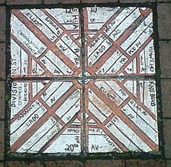
 Brick map of Ladd's Addition that was at the corner of SE 34th Avenue and SE Madison Street until roughly 2018. Brick map of Ladd's Addition that was at the corner of SE 34th Avenue and SE Madison Street until roughly 2018. | |
| Location | Portland, Oregon |
|---|---|
| Coordinates | 45°30′31″N 122°38′58″W / 45.508539°N 122.649413°W / 45.508539; -122.649413 |
| Area | 126 acres (0.51 km) |
| Built | 1905 (1905)–1930 (1930) |
| MPS | |
| NRHP reference No. | 88001310 |
| Added to NRHP | August 31, 1988 |
Ladd's Addition is an inner southeast historic district of Portland, Oregon, United States. It is Portland's oldest planned residential development, and one of the oldest in the western United States. The district is known in Portland for a diagonal street pattern, which is at odds with the rectilinear grid of the surrounding area. Roughly eight blocks (east-west) by ten blocks (north-south) in size (by reference to the surrounding grid), Ladd's is bordered by SE Hawthorne, Division, 12th, and 20th streets. It is part of the Hosford-Abernethy neighborhood association.
History
Ladd's Addition is named after William S. Ladd, a merchant and mid-19th-century Portland mayor who owned a 126-acre (51 ha) farm on the land. In 1891 (when the city of East Portland was merged into Portland) Ladd subdivided the land for residential use. Rather than follow the standard orthogonal grid of the surrounding area, Ladd created a diagonal "wagon wheel" arrangement, including four small diamond-shaped rose gardens and a central traffic circle surrounding a park. It is also one of fewer than 20 areas in Portland that have alleyways, with street elevations mostly uninterrupted by curb cuts. While it is said that Ladd's design was inspired by L'Enfant's Washington layout, it bears no actual resemblance to the Washington street plan.

The homes in the district, mostly developed between 1905 and 1930 (after Ladd's death), have been called a "architecturally rich mix of compatible early 20th century styles," notable for their "continuity of scale, setback, orientation, and materials." Architectural styles represented include bungalow, craftsman, American Foursquare, Mission, Tudor, and Colonial Revival.
Development started at the north end, closest to the streetcar transportation, with the largest homes built between 1905 and 1915.
Though the earliest deeds excluded Japanese and Chinese residents, except as servants, after those covenants expired, Ladd's Addition was one of the few areas by 1939 informally designated as open to 'oriental' families.

Ecology
The narrow streets of Ladd's Addition are lined with American Elm trees. The Save Our Elms organization inoculates the elm trees yearly against Dutch elm disease. Each of the four smaller, diamond-shaped "circles" to the east, west, north, and south contains one of Portland's rose test gardens. Friends of Ladd's Addition Gardens regularly solicits money and volunteers to maintain the rose gardens. Ladd named most of the streets after trees, but he named SE Ladd Avenue and SE Elliott Avenue for himself and his wife, who was born Caroline Elliott.
Historic preservation
The area was designated a historic district by the National Register of Historic Places in 1988.
See also
- Ladd Carriage House
- Meridian, Seattle
- St. Sharbel Maronite Catholic Church
- Tangletown, Minneapolis
- Longview, Washington
Notes
- Although Ladd's Addition has not been formally, administratively associated with a National Register multiple property submission, it was featured in the background documentation for the Historic Residential Suburbs in the United States, 1830–1960, MPS.
References
- General references
- Portland Monthly, April 2007, 20 Best Neighborhoods, pages 78–79.
- Citations
- ^ "Community History - Ladd's Addition, Portland". Illustrating Four Treatments in Oregon. National Park Service. Retrieved April 15, 2012.
- McClelland, Linda Flint; Ames, David L.; Pope, Sarah Dillard (December 22, 2004), National Register of Historic Multiple Property Documentation Form: Historic Residential Suburbs in the United States, 1830–1960 (PDF), retrieved December 23, 2016.
- "Ladd Circle Park & Rose Gardens". Portland Parks & Recreation. Retrieved April 15, 2012.
- "PDX Alleys". Google maps. Retrieved October 3, 2018.
- ^ "Ladd's Addition".
- "History of Save Our Elms". Archived from the original on October 8, 2007. Retrieved August 30, 2007.
- "Ladd's Addition Rose Garden". Portland Rose Festival Association. Retrieved August 30, 2007.
- "Friends of Ladd's Addition Gardens". laddsadditiongardens.com. Retrieved August 30, 2007.
- Snyder, Eugene E. (1979). Portland Names and Neighborhoods. Portland: Binford and Mort. p. 38. ISBN 978-0832303470.
- "Oregon National Register List" (PDF). oregon.gov. Archived from the original (PDF) on June 9, 2011. Retrieved August 30, 2007.
External links
- [REDACTED] Media related to Ladd's Addition, Portland, Oregon at Wikimedia Commons
| Neighborhoods of Portland, Oregon | |
|---|---|
| Neighborhood Associations |
|
| Other areas | |
| U.S. National Register of Historic Places in Oregon | ||
|---|---|---|
| Lists by county | [REDACTED]  | |
| Portland lists | ||
| Other lists | ||