You can help expand this article with text translated from the corresponding articles in Russian and Finnish. (May 2024) Click for important translation instructions.
|
| This article relies largely or entirely on a single source. Relevant discussion may be found on the talk page. Please help improve this article by introducing citations to additional sources. Find sources: "Lake Leksozero" – news · newspapers · books · scholar · JSTOR (May 2024) |
| Lake Leksozero | |
|---|---|
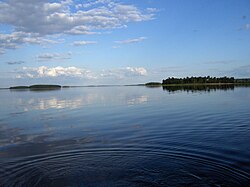
 View from the Repola village View from the Repola village | |
  | |
| Location | Republic of Karelia |
| Coordinates | 63°46′00″N 30°58′00″E / 63.766667°N 30.966667°E / 63.766667; 30.966667 |
| Basin countries | Russia |
| Surface area | 166 km (64 sq mi) |
| Average depth | 8.5 m (28 ft) |
| Max. depth | 34 m (112 ft) |
| Water volume | 1.408 km (1,141,000 acre⋅ft) |
| Surface elevation | 174 m (571 ft) |
| Frozen | November–May |
Lake Leksozero (Russian: Лексозеро, Karelian: Lieksajärvi) is a large freshwater lake in the Republic of Karelia, Russia. It has an area of 166 km² and an average depth of 8.6 m. It freezes up in November and stays icebound until May. There are many islands on the lake. Leksozero is used for fishery. The lake drains through the river Lieksanjoki that flows into the lake Pielinen in Northern Karelia, Finland. These lakes are part of the Vuoksi River basin in Finland and Russia, which in turn is part of the Neva River basin in Russia.
References
This Republic of Karelia location article is a stub. You can help Misplaced Pages by expanding it. |