| Lake Nakivale | |
|---|---|
| Lake Nakivali | |
 Lake Nakivale Lake Nakivale | |
| Location | Isingiro district |
| Basin countries | Uganda |
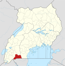
Lake Nakivali, also known as Lake Nakivale, is a freshwater lake located in western Uganda's Isingiro District; it is part of the Lake Mburo-Nakivale wetland system. It is located about 40 kilometers south-east of Mbarara town.
Biodiversity
Lake Nakivale have 9 fish species (4 haplochromines and 5 non-haplochromines) were discovered. Catches were dominated by cichlids (tilapiines and Nkejje haplochromines). By numbers, the haplochromines dominated by Astatotilapia aeneocolor,(89%) was the most numerous species while the tilapias Oreochromis esculentus, Oreochromis niloticus and Oreochromis leucostictus followed (8%). Mamba Protopterus aethiopicus (2%) was third. The other fish species of commercial importance, Male Clarias gariepinus contributed 0.25%.
Settlements

The lake serves both the refugees in the Nakivale Refugee Settlement and Ugandan nations in the areas next to the Lake. It has been under threat due to the massive pollution from silting following the massive deforestation due to the setting up the refugee camps although the refugees have taken the lead role in the conservation and protection of the lake.On a rocky escarpment on a hill at Nakivale refugee settlement, a group of workers use hand-held tools to dig a series of holes,lowers in pine-tree seedlings and then covers them up in order to restore back the forest. A view from Nakivale Refugee Settlement indicates green valley leading to Lake Nakivale. Some people were evicted from Lake Nakivale protection zones.
Activities
- Crop cultivation on the shores of lake Nakivale is causing silting and shrinking of the water levels
- Deforestation
- Illegal and excessive fishing, over 70% of the inhabitants around the lake live on fishing
- Agricultural activities like farming, livestock rearing, causes pollution of the water
- Other human activities like brick making around the shores of the lake lead to pollution of the water
- Children swim in the section of lake while others draw water for home use
Ecosystem collapse
Gauges within Lake Nakivale indicate that the lake basin has been covered by silt reducing the depth of the lake by 4m and besides that the surface area(width) has been reduced by 10m from the shores. The continuous inflow of silt into 25 square kilometre lake Nakivale has turned the water brownish due to mud pollution. Siltation is caused by poor vegetation managemnet for example tree cutting on Ngarama and Kabingo hills as well as over grazing, bushfires, charcoal burning and lack of terraces.
See also
References
- "Lake Nakivale, Lake Mburo National Park". Inside Lake Mburo National Park. Retrieved 2024-05-26.
- "Lake Nakivale". Mbarara Tours. Retrieved 2024-05-26.
- LAKE NAKIVALE FISHERIES REPORT. National Fisheries Resources Research Institute. pp. 17–18.
- The fisheries resources of Lake Nakivali: report of a rapid assessment of the Lake Nakivali fishery. Jinja, Uganda: National Fisheries Resources Research Institute. 2010. hdl:1834/35543.
- ^ "A refugees' idea to restore a degraded Ugandan lake pays off". New Vision. Retrieved 2024-06-05.
- AfricaNews (4 January 2024). "Uganda: Refugees in Nakivale one of Africa's oldest settlements replant lost forests". Africanews. Retrieved 2024-06-26.
- "Uganda's generosity to refugees continues despite limited resources". UNHCR Africa. Retrieved 2024-06-26.
- Mariam, Kabasongora (11 Mar 2013). "Lake Nakivale Evictees Sue Nema For Property Destruction".
- "L.Nakivale in danger". New Vision. Retrieved 2024-06-13.
- ^ "Lake Nakivale Archives - Water Journalists Africa". 2021-02-16. Retrieved 2024-06-13.
- ^ "Siltation and sediment is clogging up Lake Nakivale". New Vision. Retrieved 2024-06-29.
External links
0°46′48″S 30°53′17″E / 0.78000°S 30.88806°E / -0.78000; 30.88806
Categories: