Unincorporated community in Kentucky, United States
| Leatherwood | |
|---|---|
| Unincorporated community | |
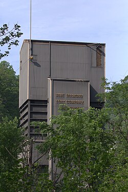
 Coal facility in Leatherwood, Kentucky. Coal facility in Leatherwood, Kentucky. | |
  | |
| Coordinates: 37°1′58″N 83°5′2″W / 37.03278°N 83.08389°W / 37.03278; -83.08389 | |
| Country | United States |
| State | Kentucky |
| County | Perry |
| Elevation | 1,719 ft (524 m) |
| Time zone | UTC-5 (Eastern (EST)) |
| • Summer (DST) | UTC-4 (EDT) |
| GNIS feature ID | 513280 |
Leatherwood is an unincorporated community within Perry County, Kentucky, United States. At one point, it was called Toner. The post office has been closed.

References
- U.S. Geological Survey Geographic Names Information System: Leatherwood, Kentucky
- U.S. Geological Survey Geographic Names Information System: Leatherwood, Kentucky
| Municipalities and communities of Perry County, Kentucky, United States | ||
|---|---|---|
| County seat: Hazard | ||
| Cities |  | |
| CDPs | ||
| Other unincorporated communities |
| |
| Ghost town | ||
| Former mining towns | ||
| Post offices (and the creeks they are on) |
| |
This Perry County, Kentucky state location article is a stub. You can help Misplaced Pages by expanding it. |