Misplaced Pages

Lerhupur

Article snapshot taken from[REDACTED] with creative commons attribution-sharealike license. Give it a read and then ask your questions in the chat. We can research this topic together.

Census town in Uttar Pradesh, India
Lerhupur
Census town
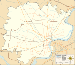
LerhupurLerhupurLerhupurCensus town location on Varanasi district mapShow map of Varanasi districtLerhupurLerhupurLerhupurLerhupur (Uttar Pradesh)Show map of Uttar PradeshLerhupurLerhupurLerhupurLerhupur (India)Show map of India
Coordinates: 25°21′28″N 83°02′25″E / 25.357836°N 83.040165°E / 25.357836; 83.040165
Country India
StateUttar Pradesh
DistrictVaranasi district
TehsilVaranasi tehsil
Elevation78 m (256 ft)
Population
 • Total6,934
Languages
 • OfficialHindi & English
Time zoneUTC+5:30 (IST)
Postal code221007
Telephone code+91-542
Vehicle registrationUP65 XXXX
Census town & village code209748
Lok Sabha constituencyVaranasi (Lok Sabha constituency)
Vidhan Sabha constituencyVaranasi Cantt.

Lerhupur is a census town in Varanasi tehsil of Varanasi district in the Indian state of Uttar Pradesh. The census town & village falls under the Ladhupur gram panchayat. Lerhupur Census town & village is about 8 kilometers North-West of Varanasi railway station, 305 kilometers South-East of Lucknow and 17 kilometers North-West of Banaras Hindu University.

Demography

Ledhupur has families with a total population of 6,934. Sex ratio of the census town & village is 876 and child sex ratio is 902. Uttar Pradesh state average for both ratios is 912 and 902 respectively .

Details Male Female Total Comments
Number of houses - - 1,057 (census 2011)
Adult - - 5,808
Children - - 1,126
Total population 3,696 3,238 6,934
Literacy 78.9% 62.2% 71.1%

Transportation

Lerhupur is connected by air (Lal Bahadur Shastri Airport), by train (Varanasi railway station) and by road. Nearest operational airports is Lal Bahadur Shastri Airport and nearest operational railway station is Varanasi railway station (25 and 8 kilometers respectively from Lerhupur).

See also

Portal:

Notes

References

  1. ^ "Demography". 2011 Census of India website. Retrieved 23 November 2015.
  2. ^ "Delimitation 2008" (PDF). Election Commission of India website. Retrieved 23 November 2015.
  3. ^ "Census town & village details". Local Government directory. Retrieved 23 November 2015.
  4. "Census town & village coordinates". latlong.net. Retrieved 23 November 2015.
  5. "Elevation". daftlogic.com. Retrieved 23 November 2015.
Varanasi
History
Intentionally left blank for sometime
Administrative
division
DivisionsVaranasi division
DistrictsVaranasi district
TehsilsPindra, Varanasi
Census townsAmara Khaira Chak, Benipur, Bhagawanpur, Birbhanpur, Dindaspur, Gangapur, Harpal Pur, Kakarmatta, Kandwa, Kotwa, Lohta, Maruadih, Phulwaria, Ramnagar, Salarpur, Shivdaspur, Sir Gobardhan, Susuwahi, Suzabad, Umarha, Varanasi, Varanasi cantt.
Villages
Villages in Varanasi district
Pindra
Tehsil
Varanasi
Tehsil
flag India portal
Languages &
dialects spoken
Bengali
Bhojpuri
English
Hindi
Hindustani
Urdu
Political
representation
MP
Narendra Modi (Incumbent Prime Minister of India)
MLA
Avadhesh Singh
Anil Rajbhar
Kailash Nath Sonkar
Neelkanth Tiwari
Neel Ratan Singh Patel
Ravindra Jaiswal
Saurabh Srivastava
Surendra Narayan Singh
Constituency
Lok Sabha
Varanasi
Vidhan Sabha
Ajagara
Pindra
Rohaniya
Sevapuri
Shivpur
Varanasi Cantt.
Varanasi North
Varanasi South
Transportation
Air
Lal Bahadur Shastri Airport
Rail
Babatpur
Bhulanpur
Kashi
Manduadih
Varanasi Junction
Varanasi City
Varanasi Metro
Road
Grand Trunk Road
National Highway 28
National Highway 35
Malviya Bridge
Water
Varanasi Multi-Modal Terminal
Education
Universities
Banaras Hindu University
IIT (BHU) Varanasi
Central Institute of Higher Tibetan Studies
Mahatma Gandhi Kashi Vidyapith
Sampurnanand Sanskrit Vishwavidyalaya
Colleges
Arya Mahila Mahavidyalaya
DAV Post Graduate College
Harish Chandra Postgraduate College
Sri Agrasen Kanya P.G. College
Subhash Chandra Mahavidyalaya
Sunbeam College for Women
Vasant Kanya Mahavidyalaya
Vasanta College for Women
CBSE schools
Central Hindu Boys School
Central Hindu Girls School
Delhi Public School
KV-BHU
UP board schools
C.M. Anglo Bengali College
ICSE schools
St Joseph's Convent School
St. John's School, Varanasi
W. H. Smith Memorial School
Places of
worship
Buddhist temples
Sarnath
Churches
St. Mary's Cathedral
Hindu
temples
Aghori
Baba Keenaram Sthal
Bharat Mata
Bharat Mata Mandir
Durga or her avatar
Durga Mandir
Sankata Devi Mandir
Hanuman
Sankat Mochan Hanuman Temple
Parvati or her avatar
Annapurna Devi Mandir
Lalita Gauri Mandir
Vishalakshi Temple
Shiva or his avatar
Kaal Bhairav Mandir
Kashi Vishwanath Temple
Mrityunjay Mahadev Mandir
Nepali Mandir
Shri Vishwanath Mandir
Shri Tilbhandeshwar Mahadev Mandir
Others
Tulsi Manas Mandir
Mosques
Gyanvapi Mosque
Alamgir Mosque
Ravidasis
Shri Guru Ravidass Janam Asthan
Ghats
Assi Ghat
Dashashwamedh Ghat
Ganga Mahal Ghat (I)
Lalita Ghat
Manikarnika Ghat
Munshi Ghat
Sant Ravidas Ghat
Scindia Ghat
Tulsi Ghat
Point of interest
Ashoka Stambh
Bharat Kala Bhavan
Bharat Mata Mandir
Ganges
Ghats
Jantar Mantar
Ramnagar Fort
Hospitals
Sir Sunderlal Hospital
Places adjacent to Lerhupur
Lal Bahadur Shastri Airport (25 km) Sarnath (3 km)
Paharia (3.5 km) Lerhupur Chiraigaon (1.5 km)
Bhelupur (11 km) Vasanta College for Women (6.5 km)
Categories:
Lerhupur Add topic