"Lithonia" redirects here. For the song, see Lithonia (song). City in Georgia, United States
| Lithonia, Georgia | |
|---|---|
| City | |
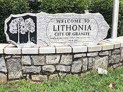
 Welcome sign on Main Street in Lithonia Welcome sign on Main Street in Lithonia | |
| Motto: City of Granite | |
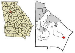
 Location in DeKalb County and the state of Georgia Location in DeKalb County and the state of Georgia | |
 | |
| Coordinates: 33°42′46″N 84°6′21″W / 33.71278°N 84.10583°W / 33.71278; -84.10583 | |
| Country | United States |
| State | Georgia |
| County | DeKalb |
| Government | |
| • Mayor | Shameka Reynolds |
| • DeKalb County CEO | Michael L. Thurmond |
| Area | |
| • Total | 0.93 sq mi (2.41 km) |
| • Land | 0.93 sq mi (2.40 km) |
| • Water | 0.00 sq mi (0.00 km) |
| Elevation | 925 ft (282 m) |
| Population | |
| • Total | 2,662 |
| • Density | 2,868.53/sq mi (1,107.78/km) |
| Time zone | UTC-5 (Eastern (EST)) |
| • Summer (DST) | UTC-4 (EDT) |
| ZIP codes | 30038, 30058 |
| Area code(s) | 770, |
| FIPS code | 13-46860 |
| GNIS feature ID | 0325978 |
| Website | cityoflithoniaga |
Lithonia (/lɪˈθoʊniə/ lih-THOH-nee-ə, AAVE: /laɪ-/ ly-) is a city in eastern DeKalb County, Georgia, United States. The city's population was 2,662 at the 2020 census. Lithonia is in the Atlanta metropolitan area.
"Lithonia" means "city/town of stone". Lithonia is in the heart of the Georgian granite-quarrying and viewing region, hence the name of the town, from the Greek lithos, for “stone”. The huge nearby Stone Mountain is composed of granite, while the Lithonia gneiss is a form of metamorphic rock. The Stone Mountain granite is younger than, and has intruded the Lithonia gneiss. The area has a history of rock quarries. The mines were served by the Georgia Railroad and Atlanta, Stone Mountain & Lithonia Railway. Some of the rock quarries have been converted to parkland, and the rail lines to rail-trail.
Lithonia is one of the gateways to the Arabia Mountain National Heritage Area, which is largely contained inside Stonecrest, Georgia.
Geography
Lithonia is located in southeastern DeKalb County at 33°42′46″N 84°6′21″W / 33.71278°N 84.10583°W / 33.71278; -84.10583 (33.712658, -84.105897). Interstate 20 passes just south of the community, with access from Exits 74 and 75. Lithonia is 18 miles (29 km) east of the center of Atlanta. Some areas in extreme southern Gwinnett County use a Lithonia postal address near the county line.
According to the United States Census Bureau, the city has a total area of 0.89 square miles (2.3 km), all land.
History

In 1805, Lithonia began as a small crossroads settlement of farmers. The town grew with the coming of the Atlanta Augusta Railroad in 1845, which allowed the granite quarrying industry in the area to flourish.
Lithonia is the birthplace of the Lithonia Lighting company, one of North America's largest manufacturers of commercial, institutional, industrial and residential light fixtures, which was founded in the city in 1946 but moved to nearby Conyers in the 1950s.
New Birth Missionary Baptist Church, a megachurch which is known for many high-profile funerals, is located in Stonecrest, GA, near Lithonia.
Lithonia Historic District

| Lithonia Historic District | |
| U.S. National Register of Historic Places | |
| U.S. Historic district | |
| Area | 441 acres (178 ha) |
|---|---|
| NRHP reference No. | 16000639 |
| Added to NRHP | September 19, 2016 |
The Lithonia Historic District consists of a commercial core surrounded by residential areas, with a period of significance spanning from 1845 to 1964. Stylistic influences in the district include Second Empire, Queen Anne, Folk Victorian, Neoclassical Revival, English Vernacular Revival, Craftsman, and Colonial Revival. The district is bisected by the Georgia/CSX Railroad, which runs perpendicular to the historic commercial core's primary thoroughfare, Main Street. The commercial area extends south from the intersection of Main Street and the railroad, covering a two-block area. The commercial buildings are primarily brick and local granite masonry, with little decorative detailing. Commercial styles include single retail, multiple retail, and retail and office types. Within the historic district, there is some non-historic infill construction such as the 1968 Lithonia Plaza shopping center.

The residential areas consist architecture typical of late 19th- to mid 20th-century types and styles. Residential neighborhoods also feature locally quarried granite and gneiss. House types and styles include the central hall Georgian cottage, gabled-wing cottage, Queen Anne cottage, New South cottage, pyramid cottage, bungalow, Ranch house, I-House and Queen Anne house.
Landmark properties include the Masonic Lodge (1916), The Lithonia Women's Club (1928), the Lithonia First United Methodist Church (1910), Antioch Baptist Church (1911), Lithonia Presbyterian Church, The Union Missionary Church (1911), the Bruce Street equalization school (c.1953), and The Seminary (1895). Contributing sites in the district include two cemeteries, two parks, the former Georgia Railroad Quarry, and the ruins of the Bruce Street School for African-Americans (1938).
The district is significant under National Register criterion A (association with historic events) and C (architecture), with areas of significance in Architecture, Black and European Ethnic Heritage, Community Planning and Development, Industry, and Transportation.
Demographics
| Census | Pop. | Note | %± |
|---|---|---|---|
| 1880 | 266 | — | |
| 1890 | 1,182 | 344.4% | |
| 1900 | 1,208 | 2.2% | |
| 1910 | 1,428 | 18.2% | |
| 1920 | 1,269 | −11.1% | |
| 1930 | 1,457 | 14.8% | |
| 1940 | 1,554 | 6.7% | |
| 1950 | 1,538 | −1.0% | |
| 1960 | 1,667 | 8.4% | |
| 1970 | 2,270 | 36.2% | |
| 1980 | 2,637 | 16.2% | |
| 1990 | 2,448 | −7.2% | |
| 2000 | 2,187 | −10.7% | |
| 2010 | 1,924 | −12.0% | |
| 2020 | 2,662 | 38.4% | |
| U.S. Decennial Census 1850-1870 1870-1880 1890-1910 1920-1930 1940 1950 1960 1970 1980 1990 2000 2010 | |||
| Race | Num. | Perc. |
|---|---|---|
| White (non-Hispanic) | 128 | 4.81% |
| Black or African American (non-Hispanic) | 2,212 | 83.1% |
| Native American | 3 | 0.11% |
| Asian | 18 | 0.68% |
| Other/Mixed | 98 | 3.68% |
| Hispanic or Latino | 203 | 7.63% |
As of the 2020 United States census, there were 2,662 people, 938 households, and 524 families residing in the city.
Shopping
Lithonia is near to a super-regional shopping center, the Mall at Stonecrest (also known as Stonecrest Mall), and serves as the northernmost point on the Arabia Mountain Path. Much of the mall's available property has yet to be developed.
Hospitals
The three main health facilities in Lithonia are:
- Emory Hillandale Hospital is the newest hospital in DeKalb.
- Kaiser Permanente runs two community health clinics in Lithonia: Panola Road Clinic, and the Stonecrest Clinic.
- East DeKalb Health Center
Education
DeKalb County Public Schools operates public schools. Lithonia Middle School is the only school located in the city limits of Lithonia.
The schools that serve the city limits of Lithonia are: Stoneview Elementary School in Stonecrest, Lithonia Middle School, and Lithonia High School in Stonecrest (formerly Redan CDP).
Elementary schools in the wider surrounding area:
- Edward L. Bouie Sr. Elementary
- Marbut Elementary
- Shadow Rock Elementary
- Rock Chapel Elementary
- Princeton Elementary
- Redan Elementary
- Flat Rock Elementary
- Fairington Elementary
- Stoneview Elementary
- Panola Way Elementary
- Murphy Candler Elementary
- Browns Mill Elementary
- Wynbrooke Traditional Theme School
Middle schools in the surrounding area:
- Lithonia Middle School
- Redan Middle School
- Salem Middle School
- Miller Grove Middle School
- DeKalb Academy of Technology and Environment
High schools in the surrounding area:
- Lithonia High School (Primary Zoned High School)
- Martin Luther King, Jr. High School (Secondary Zoned High School)
- Miller Grove High School (Relief High School)
- Arabia Mountain High School (Magnet High School)
Universities
- Luther Rice University of Theological Studies
- Strayer University
Public libraries
DeKalb County Public Library operates the Lithonia-Davidson Library the main library source in Lithonia, which was once privately owned until being incorporated into the DeKalb County Public Library system in 1947.
Other libraries in the Lithonia area include:
- Salem- Panola Branch
- Redan- Trotti Branch
- Stonecrest- Klondike Branch
Parks
- Browns Mill/Recreation Center
- Bruce Street Park
- Davidson-Arabia Mountain/Preserve
- Fairington Park
- Lithonia Park
- Mystery Valley Golf Course
- Redan Park (included Disc Golf, Tennis course, baseball and football fields, pavilion and family kids play areas)
- Southeast Athletic Complex
- Rock Chapel Park
- Salem Park
Postal service
Lithonia's main post office is located on Stone Mountain Street in the heart of Lithonia. Many drop boxes and postal services storefronts are located throughout the communities of Lithonia.
Redan post office located directly outside the city limits of Lithonia provides an alternative to postal drop off and pickup service.
United Parcel Service (UPS) and FedEx also provide alternative postal service to Lithonia.
Transportation
MARTA (Metropolitan Atlanta Rapid Transit Authority) provides connecting bus service to and from Lithonia, and GRTA Xpress (Georgia Rapid Transit Authority) provides commuter bus service to downtown Atlanta from a community park and ride lot.
In popular culture
The city was the title subject of the 2024 Childish Gambino song of the same name, Lithonia.
References
- "2020 U.S. Gazetteer Files". United States Census Bureau. Retrieved December 18, 2021.
- "U.S. Census website". United States Census Bureau. Retrieved January 31, 2008.
- "US Board on Geographic Names". United States Geological Survey. October 25, 2007. Retrieved January 31, 2008.
- Krakow, Kenneth K. (1975). Georgia Place-Names: Their History and Origins (PDF). Macon, GA: Winship Press. p. 132. ISBN 0-915430-00-2.
- arabiaalliance.org
- "US Gazetteer files: 2010, 2000, and 1990". United States Census Bureau. February 12, 2011. Retrieved April 23, 2011.
- "Geographic Identifiers: 2010 Demographic Profile Data (G001): Lithonia city, Georgia". U.S. Census Bureau, American Factfinder. Retrieved October 21, 2015.
- ^ "SUMMARY OF PROPOSED NATIONAL REGISTER/GEORGIA REGISTER NOMINATION" (PDF). Georgia Department of Natural Resources Historic Preservation Division. January 2014. Archived from the original on April 16, 2015.
- "National Register Information System". National Register of Historic Places. National Park Service. November 2, 2013.
- "Decennial Census of Population and Housing by Decade". United States Census Bureau.
- "1870 Census of Population - Georgia - Population of Civil Divisions less than Counties" (PDF). United States Census Bureau. 1870.
- "1880 Census of Population - Georgia - Population of Civil Divisions less than Counties" (PDF). United States Census Bureau. 1880.
- "1910 Census of Population - Georgia" (PDF). United States Census Bureau. 1910.
- "1930 Census of Population - Georgia" (PDF). United States Census Bureau. 1930. pp. 251–256.
- "1940 Census of Population - Georgia" (PDF). United States Census Bureau. 1940.
- "1950 Census of Population - Georgia" (PDF). United States Census Bureau. 1950.
- "1960 Census of Population - Population of County Subdivisions - Georgia" (PDF). United States Census Bureau. 1960.
- "1970 Census of Population - Population of County Subdivisions - Georgia" (PDF). United States Census Bureau. 1970.
- "1980 Census of Population - Number of Inhabitants - Georgia" (PDF). United States Census Bureau. 1980.
- "1990 Census of Population - Summary Social, Economic, and Housing Characteristics - Georgia" (PDF). United States Census Bureau. 1990.
- "2000 Census of Population - General Population Characteristics - Georgia" (PDF). United States Census Bureau. 2000.
- "2010 Census of Population - General Population Characteristics - Georgia" (PDF). United States Census Bureau. 2010.
- "Explore Census Data". data.census.gov. Retrieved December 13, 2021.
- "Arabia Mountain PATH - Arabia Mountain National Heritage Area". arabiaalliance.org.
- "Official Zoning Map." City of Lithonia. Adopted July 6, 2015. Retrieved on June 1, 2017.
- "Home". Lithonia Middle School. Retrieved February 19, 2023.
2451 Randall Avenue Lithonia, GA 30058
- No other school resolves to within the Lithonia city limits. - "Elementary School Attendance Areas 2018 - 2019 School Year." DeKalb County School System. Retrieved on February 19, 2023.
- "Middle School Attendance Areas 2018 - 2019 School Year." DeKalb County School System. Retrieved on February 19, 2023.
- "High School Attendance Areas 2018 - 2019 School Year." DeKalb County School System. Retrieved on February 19, 2023.
External links
| Municipalities and communities of DeKalb County, Georgia, United States | ||
|---|---|---|
| County seat: Decatur | ||
| Cities |  | |
| CDPs | ||
| Neighborhoods and unincorporated communities | ||
| Ghost town | ||
| Footnotes | ‡This populated place also has portions in an adjacent county or counties | |