| Madira Bickel Mound State Archaeological Site | |
|---|---|
| IUCN category V (protected landscape/seascape) | |
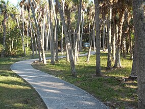
 Path leading to the mound Path leading to the mound | |
  | |
| Location | Manatee County, Florida, USA |
| Nearest city | Palmetto, Florida |
| Coordinates | 27°33′55″N 82°35′34″W / 27.56528°N 82.59278°W / 27.56528; -82.59278 |
| Area | 10 acres (0.040 km) |
| Established | August 12, 1970 (1970-08-12) |
| Governing body | Florida Department of Environmental Protection |
The Madira Bickel Mound State Archaeological Site is an archaeological site on Terra Ceia Island in northwestern Palmetto, Florida, United States. It is located on Bayshore Drive, west of U.S. 19, a mile south of I-275. On August 12, 1970, it was added to the U.S. National Register of Historic Places. It is also a Florida State Park.
The 10-acre (0.040 km) site was the first Native American location in Florida to be designated as a State Archaeological Site.
History
Archaeological excavations have established that indigenous occupation reaches back 2,000 years, and across three distinct periods: Manasota, Weedon Island, and Safety Harbor cultures. The people constructed a massive earthwork temple/ceremonial mound from shells, sand and detritus. It is still 20-foot (6.1 m) high, with a base nearly 100 by 170 feet (52 m).
Scholars believe that the mound site continued to be of great ceremonial importance to the historic Tocobaga Indians of the surrounding area, who coalesced as a people before European encounter in the late sixteenth century. They survived into the eighteenth century but disappeared as a tribe due to infectious diseases and warfare.
The site is named for Madira Bickel of Sarasota. She and her husband, Karl, purchased the land around the main mound and donated it to the state in 1948.
The mounds
The point of greatest interest at the site is the 20-foot (6.1 m) high temple/ceremonial mound. Composed of shells (obtained from a midden to the west), sand, and detritus, the mound's base is 100 feet (30 m) by 170 feet (52 m). To more easily reach the top, the Tocobaga constructed a curved 10-foot (3.0 m) wide ramp on the western side.
The state park has graduated stairways for access, and at the top, has cleared an area (protected by a fence) for overlooking the park. Over the centuries, the mound has become covered with vegetation, including tall trees.
Also in the park are the remains of the Prine Burial Mound, which is circular, about 40 feet (12 m) wide, and about 2 feet (0.61 m) high at the center. It was used through the three major archaeological cultures described above, from 800-1500 AD. Since settlement and development, much of the mound's contents have been disturbed.
References
- "Welcome to Madira Bickel Mound State Archaeological Site". Florida State Parks. Retrieved April 23, 2018.
External links
- Madira Bickel Mounds State Archaeological Site at Florida State Parks
- Manatee County listings, Florida's Office of Cultural and Historical Programs
- "Madira Bickel Temple Mound Site", School District of Manatee County
- Madira Bickel Mound Photograph Gallery, Florida Center for Instructional Technology, University of South Florida
- IUCN Category V
- Archaeological sites on the National Register of Historic Places in Florida
- National Register of Historic Places in Manatee County, Florida
- Parks in Manatee County, Florida
- Protected areas established in 1970
- State parks of Florida
- Florida Native American Heritage Trail
- Mounds in Florida
- 1970 establishments in Florida
