| Maine | |
|---|---|
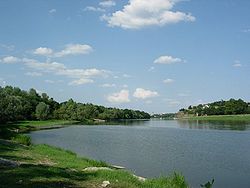
 The Maine near Angers The Maine near Angers | |
  | |
| Native name | La Maine (French) |
| Location | |
| Country | France |
| Physical characteristics | |
| Source | |
| • location | Sarthe and Mayenne |
| • elevation | ±25 m (82 ft) |
| Mouth | |
| • location | Loire |
| • coordinates | 47°24′39″N 0°36′53″W / 47.41083°N 0.61472°W / 47.41083; -0.61472 |
| Length | 11.5 km (7.1 mi) |
| Basin size | 22,194 km (8,569 sq mi) |
| Discharge | |
| • average | 128 m/s (4,500 cu ft/s) |
| Basin features | |
| Progression | Loire→ Atlantic Ocean |
The Maine (French pronunciation: [mɛːn] ) is a river, a tributary of the Loire, 11.5 km (7.1 mi) long, in the Maine-et-Loire département in France.

It is formed by the confluence of the Mayenne and Sarthe rivers north of Angers. It flows through this city and joins the Loire southwest of Angers.
The river's name is derived from the ancient Meodena, as is Mayenne, and is unrelated to Maine, the province.
References
This Maine-et-Loire geographical article is a stub. You can help Misplaced Pages by expanding it. |
This article related to a river in France is a stub. You can help Misplaced Pages by expanding it. |