| Native name: Isla de Malpelo | |
|---|---|
 Profile of Malpelo Island Profile of Malpelo Island | |
  | |
| Geography | |
| Location | Pacific Ocean |
| Coordinates | 04°00′12.038″N 81°36′27.259″W / 4.00334389°N 81.60757194°W / 4.00334389; -81.60757194 |
| Area | 1.2 km (0.46 sq mi) |
| Length | 1.643 km (1.0209 mi) |
| Width | 0.727 km (0.4517 mi) |
| Highest elevation | 360 m (1180 ft) |
| Highest point | Cerro La Mona |
| Administration | |
| Department | Valle del Cauca |
| Municipality | Buenaventura |
| Demographics | |
| Population | Uninhabited |
| UNESCO World Heritage Site | |
| Official name | Malpelo Fauna and Flora Sanctuary |
| Type | Natural |
| Criteria | vii, ix |
| Designated | 2006 |
| Reference no. | 1216 |
| Region | Latin America and the Caribbean |

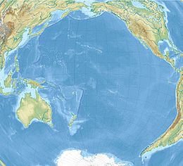
Malpelo is a small oceanic island in the eastern Pacific Ocean, located about 500 km (310 mi) west of the Colombian mainland with a military post manned by the Colombian Armed Forces. It consists of a sheer and barren rock with three high peaks, the highest being the 300 m (980 ft) Cerro de la Mona. The island is about 1.5 kilometres (1 mile) in length from northeast to southwest, and 640 metres (700 yards) across at its widest.
Geography
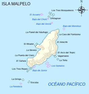
Malpelo is the only island that rises above the surface from the Malpelo Ridge, which is a solitary volcanic submarine ridge that extends in a northeast-southwest direction for 300 km (190 mi) and has a width of 100 km (62 mi). This island is surrounded by a number of offshore rocks. Off the northeast corner are the Tres Mosqueteros. Off the southwest corner are Salomón, Saúl, La Gringa, and Escuba. All the rocks are surrounded by deep water, and most of the face of the main island is very steep. Soundings between 1,800 and 9,100 metres (1,000 and 5,000 fathoms) are obtainable within a few kilometres of the shore and the currents are strong and changeable. As an oceanic island, it has never been connected with any other islands or the mainland.
Malpelo Island is composed of Miocene pillow lavas, volcanic breccias, and basaltic dikes that have been dated as being 16 to 17 million years old. This island and the underlying and underwater Malpelo Ridge were created along with the Carnegie Ridge in the Late Miocene by a very complex interaction between the Cocos-Nazca Spreading Centre and the Galápagos hotspot.
History
Prehistory
Malpelo Island was presumably isolated from human contact prior to European discovery. It is uninhabited, and is located in the same area as other oceanic eastern Pacific islands, such as Cocos Island, Galápagos and the Revillagigedo Islands, which were all uninhabited at the time of European discovery, and possibly throughout their entire history prior to that.
Discovery
The exact date of Malpelo's discovery is unclear, although it may have been the first of the remote eastern Pacific islands to have been discovered by Europeans, as it appears on Peruvian maps from as early as 1530. Malpelo became a possession of Spain following its discovery, and was subsequently annexed by Peru, and later Colombia.
Natural history
At first glance, the island seems to be barren rock, devoid of all vegetation, but deposits of bird guano have helped colonies of algae, lichens, mosses, and some shrubs and ferns establish, all of which glean nutrients from the guano. Lizards are the only non-avian vertebrates on the island, with three species total.
- Agassiz's anole (Anolis agassizi)
- Dotted galliwasp (Diploglossus millepunctatus)
- Colombian leaf-toed gecko (Phyllodactylus transversalis)
It is also home to a unique species of land crabs, Johngarthia malpilensis, first described in 1893.
The island has been recognised as an Important Bird Area (IBA) by BirdLife International because it supports a breeding population of some 60,000–110,000 Nazca boobies, as estimated in 2007.
Malpelo is home of a unique shark population; swarms of 500 hammerhead sharks and hundreds of silky sharks are frequently seen by diving expeditions, making it a very popular shark-diving location. It is one of the few places where the smalltooth sand tiger has been seen alive; it is frequently spotted at the dive site "El bajo del Monstruo". Acanthemblemaria stephensi, the Malpelo barnacle blenny, is a species of chaenopsid blenny found in coral reefs around Malpelo. The largest no-fishing zone in the East Pacific, measuring over 850,000 hectares, surrounds the island.
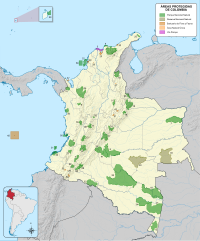
The Malpelo Nature Reserve, a plant and wildlife sanctuary, covering 857,500 ha (3,311 sq mi) centered at 04°0′12.038″N 81°36′27.259″W / 4.00334389°N 81.60757194°W / 4.00334389; -81.60757194. A Colombian foundation is trying to preserve the biodiversity of the site. On July 12, 2006, Malpelo was declared by UNESCO as a natural World Heritage Site because of its status as an important shark reserve.
Chronology
- 1530 – Malpelo is said to have been recorded in a map of this date.
- 1542 – Cristóbal Vaca de Castro visited.
- 1550 – Malpelo was recorded in Pierre Desceliers' map.
- 1704 – Wreck of the English vessel Cinque Ports
- 1790 – Spanish landing on Malpelo was mentioned to Alessandro Malaspina.
- 1793 – James Colnett visited.
- 1837 – A note in The Nautical Magazine recorded a visit.
- 1995 – Malpelo was designated as a flora and fauna sanctuary.
Gallery
-
 Shore and cliffs
-
 Nazca booby Sula granti
References
- ^ "Pacific Coast: Malpelo Island". Coastal and Marine Geology Program, United States Geological Survey, Santa Cruz, California. 2010. Archived from the original on 2 February 2018.
- "Coasts of Colombia". Coastal and Marine Geology Program, United States Geological Survey, Santa Cruz, California. 2010. Archived from the original on 3 February 2018.
- ^ Marcaillou, B.; Charvis, P.; Collot, J.-Y. (2006). "Structure of the Malpelo Ridge (Colombia) from seismic and gravity modeling". Marine Geophysical Research. 27: 289–300. doi:10.1007/s11001-006-9009-y.
- Hoernle K., P. Bogaard, R. Werner, F. Hauff, B. Lissinna, G.E. Alvarado and D. Garbe-Schnberg (2002) Missing history (16–71 Ma) of the Galápagos hotspot: implications for the tectonic and biological evolution of the Americas. Geology. 30(9):795–798.
- Macnaughtan, Don (February 1, 2014). "Mystery Islands of Remote East Polynesia: Bibliography of Prehistoric Settlement on the Pitcairn Islands Group". Wordpress: Don Macnaughtan's Bibliographies – via www.academia.edu.
- ^ Wurm, Stephen A., Mühlhäusler, Peter and Tryon, Darrell T.. Atlas of Languages of Intercultural Communication in the Pacific, Asia, and the Americas, Berlin, New York: De Gruyter Mouton, 1996. https://doi.org/10.1515/9783110819724
- Rand, A.S. G.C. Gorman, and W.M. Rand. 1975. Natural history, behavior, and ecology of Anolis agassizi. Pages 27-38 in J. Graham, editor. The Biological Investigation of Malpelo Island, Colombia. Smithsonian Contributions to Zoology, No.176.
- Savage, J.M. and K.R. Lips. 1993. A review of the status and biogeography of the lizard genera Celestus and Diploglossus (Squamata: Anguidae), with description of two new species from Costa Rica. Revista de Biología Tropical, 41: 817-842.
- Huey, R.B. 1975. A new gecko from Malpelo Island (Sauria: Gekkonidae: Phyllodactylus). Pages 44-46 in J. Graham, editor. The Biological Investigation of Malpelo Island, Colombia. Smithsonian Contributions to Zoology, No.176.
- Faxon, Walter (1893). "Preliminary Descriptions of New Species of Crustacea: Gecarcinus malpilensis, sp. nov". Bulletin of the Museum of Comparative Zoölogy at Harvard College in Cambridge, Massachusetts. XXIV: 157–158. Retrieved 2023-04-13.
- "Malpelo Wildlife Sanctuary". BirdLife Data Zone. BirdLife International. 2021. Retrieved 14 February 2021.
- Schneider, P. (nd) Malpelo Island the "Mount Everest" of shark and large pelagic diving. Advanced Diver Magazine Digital. Bradenton, Florida.
- ^ "Malpelo Fauna and Flora Sanctuary". UNESCO World Heritage Centre. United Nations Educational, Scientific, and Cultural Organization.
- Fundación Malpelo y Otros Ecosistemas Marinos
- Malpelo Fauna and Flora Sanctuary in Colombia Protected Planet
![]() This article incorporates text from this source, which is in the public domain: Malpelo, Cocos, and Easter Islands. Peace handbooks. London : H.M. Stationery Office, 1920.
This article incorporates text from this source, which is in the public domain: Malpelo, Cocos, and Easter Islands. Peace handbooks. London : H.M. Stationery Office, 1920.
Further reading
- Verga, Giovanni (1936). Malpelo (in Spanish). México: Departamento de Biblioteca de la Secretaría de Educación Pública.
- Prahl, Henry von (1990). Malpelo la roca viviente (in Spanish) (1. ed.). Bogotá, Colombia: Fondo para la Protección del Medio Ambiente.
- Parques Nacionales Naturales de Colombia. Fundación Malpelo y Otros Ecosistemas Marinos. Plan de Manejo del Santuario de Flora y Fauna de Malpelo (PDF) (in Spanish). Bogotá, Colombia: Fondo para la Protección del Medio Ambiente. Retrieved 2014-01-05.
External links
- Fundación Malpelo
- UNESCO World Heritage profile
- (in German) Report on diving at Malpelo, with photos of sharks
- (in Spanish) Isla de Malpelo
| Eastern Pacific islands | |
|---|---|
| Oceanic islands located between Polynesia and the Americas, sorted by country, from north to south (excluding continental islands) | |
| Mexico | |
| France | |
| Costa Rica | |
| Colombia | |
| Ecuador | |
| Chile | |
| Recreational dive sites in Colombia | ||
|---|---|---|
| Caribbean coast |  | |
| Caribbean insular | ||
| Pacific | ||
| Andean | ||
| Treasures of Colombia | |||||||||||||||||||||||||||||
|---|---|---|---|---|---|---|---|---|---|---|---|---|---|---|---|---|---|---|---|---|---|---|---|---|---|---|---|---|---|
| |||||||||||||||||||||||||||||
| |||||||||||||||||||||||||||||
| |||||||||||||||||||||||||||||
| |||||||||||||||||||||||||||||
| Source: Wills, Fernando; et al. (2001). Nuestro patrimonio – 100 tesoros de Colombia [Our heritage – 100 treasures of Colombia] (in Spanish). El Tiempo. pp. 1–311. ISBN 958-8089-16-6. | |||||||||||||||||||||||||||||
| World Heritage Sites in Colombia | ||
|---|---|---|
| ||
