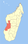
| Manja | |
|---|---|
| District | |
 | |
| Coordinates: 21°26′S 44°20′E / 21.433°S 44.333°E / -21.433; 44.333 | |
| Country | |
| Region | Menabe |
| District | Manja |
| Area | |
| • Total | 9,073 km (3,503 sq mi) |
| Elevation | 0- 350 m (−1,150 ft) |
| Population | |
| • Total | 111,430 |
| • Density | 12/km (32/sq mi) |
| Time zone | UTC3 (EAT) |
| Postal code | 616 |
Manja is a district of Menabe in Madagascar approximately 70 km in the south of the capitol Morondava. The district has an area of 9,073 km (3,503 sq mi), and the estimated population in 2020 was 111,430.
Municipalities
The district is further divided into six communes:
Rivers
The Mangoky River in the south and the Sakalava River.
References
- Estimated based on DEM data from Shuttle Radar Topography Mission
- REPOBLIKAN'I MADAGASIKARA:Tanindrazana – Fahafahana – Fandrosoana (PDF). MINISTERE DE L’AGRICULTURE, DE L’ELEVAGE ET DE LA PECHE. October 2007. pp. 42–44. Archived from the original (PDF) on 2018-06-12. Retrieved 2018-06-09.
- ^ "Madagascar: Administrative Division". citypopulation. Retrieved 10 June 2018.
| Capital: Morondava | ||
| Belo sur Tsiribihina (16) (608) |  | |
| Mahabo (12) (615) | ||
| Manja (7) (616) | ||
| Miandrivazo (16) (617) | ||
| Morondava (6) (619) | ||
| 5 districts; 57 communes | ||
This article is a stub. You can help Misplaced Pages by expanding it. |