| This article needs additional citations for verification. Please help improve this article by adding citations to reliable sources. Unsourced material may be challenged and removed. Find sources: "Mapiripán" – news · newspapers · books · scholar · JSTOR (January 2021) (Learn how and when to remove this message) |
| Mapiripán | |
|---|---|
| Municipality and town | |
 Flag Flag | |
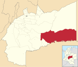
 Location of the municipality and town of Mapiripán in the Meta Department of Colombia. Location of the municipality and town of Mapiripán in the Meta Department of Colombia. | |
| Country | |
| Department | Meta Department |
| Area | |
| • Total | 11,900 km (4,600 sq mi) |
| Elevation | 250 m (820 ft) |
| Population | |
| • Total | 6,036 |
| • Density | 0.51/km (1.3/sq mi) |
| Time zone | UTC-5 (Colombia Standard Time) |
| Climate | Am |
Mapiripán is a town and municipality in the Meta Department, Colombia. It was the site of the 1997 Mapiripán Massacre.
See also
References
- "Censo Nacional de Población y Vivienda 2018" (in Spanish). DANE. Retrieved 25 April 2020.
2°53′N 72°08′W / 2.883°N 72.133°W / 2.883; -72.133
This Department of Meta location article is a stub. You can help Misplaced Pages by expanding it. |