| Marina | |
|---|---|
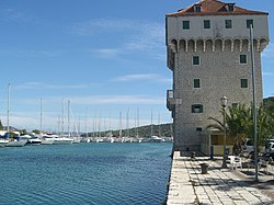
 Castle and marina in Marina Castle and marina in Marina | |
 | |
| Coordinates: 43°30′50.7″N 16°6′29.4″E / 43.514083°N 16.108167°E / 43.514083; 16.108167 | |
| Country | |
| County | Split-Dalmatia |
| Area | |
| • Total | 118.4 km (45.7 sq mi) |
| Population | |
| • Total | 4,273 |
| • Density | 36/km (93/sq mi) |
| Time zone | UTC+1 (CET) |
| • Summer (DST) | UTC+2 (CEST) |
| Website | marina |
Marina is a village and a municipality in Split-Dalmatia County, Croatia.
Population
In the 2011 census, it had a total municipality population of 4,595, in the following settlements.
- Blizna Donja, population 258
- Blizna Gornja, population 93
- Dograde, population 194
- Gustirna, population 349
- Marina, population 1,117
- Mitlo, population 75
- Najevi, population 42
- Poljica, population 681
- Pozorac, population 137
- Rastovac, population 89
- Sevid, population 267
- Svinca, population 112
- Vinišće, population 774
- Vinovac, population 75
- Vrsine, population 332
In the 2011 census, 97.6% of the population were Croats.
Geography
It is the most western municipality in Split-Dalmatia County and is bordering Šibenik-Knin County.
Marina is located on the Adriatic Highway (D8). It is a tourist village with a pebble beach shaded by olive and pine trees.
Tourism
Tourist also enjoy the atmosphere of ancient Dalmatian wine cellars, fresh fish and quality local wines, a blend of the ancient and the modern. Yachting, diving and fishing are practiced. Small yachts may dock within the small harbour and larger ones at the end of the bay, southeast of the chapel and south of the Plokata hill.
History
The settlement was planned in the 16th century. In the period 1495-1500 the bishops of Trogir built a quadrangular tower on the islet in the bay. The tower has console battlements. The channel between the mainland and the tower was filled up and levelled at the beginning of the 20th century. The structure was repaired during the Cretan war in 1657 and 1717 and reconstructed in 1971 to 1972. The church of St John has Gothic and Renaissance elements. In a field close to the village there is a small Gothic church of St. Luke with the coat of arms of the Sobota family.
References
- Register of spatial units of the State Geodetic Administration of the Republic of Croatia. Wikidata Q119585703.
- "Population by Age and Sex, by Settlements" (xlsx). Census of Population, Households and Dwellings in 2021. Zagreb: Croatian Bureau of Statistics. 2022.
- "Population by Age and Sex, by Settlements, 2011 Census: Marina". Census of Population, Households and Dwellings 2011. Zagreb: Croatian Bureau of Statistics. December 2012.
- "Population by Ethnicity, by Towns/Municipalities, 2011 Census: County of Split-Dalmatia". Census of Population, Households and Dwellings 2011. Zagreb: Croatian Bureau of Statistics. December 2012.
External links
| Subdivisions of Split-Dalmatia County | ||
|---|---|---|
| Cities and towns |  | |
| Municipalities |
| |
This Split-Dalmatia County geography article is a stub. You can help Misplaced Pages by expanding it. |