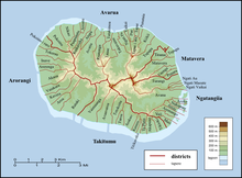
District of the island of Rarotonga in the Cook Islands
| This article needs additional citations for verification. Please help improve this article by adding citations to reliable sources. Unsourced material may be challenged and removed. Find sources: "Matavera" – news · newspapers · books · scholar · JSTOR (May 2021) (Learn how and when to remove this message) |

Matavera (traditionally known as Rangiatea) is the smallest of the five districts that make up the island of Rarotonga in the Cook Islands. It is located in the northeast of the island, to the east of the district of Avarua, and north of the district of Ngatangiia.
Matavera is subdivided into 5 tapere (out of 54 for Rarotonga), listed from west to east:
- Tupapa (Avarua District also has a Tapere named Tupapa)
- Titama
- Matavera
- Vaenga
- Pouara
References
- "Official Map of Rarotonga". Cook Islands Ministry of Justice. Retrieved 10 August 2020.
21°13′33″S 159°44′14″W / 21.225735°S 159.737341°W / -21.225735; -159.737341
This Cook Islands location article is a stub. You can help Misplaced Pages by expanding it. |