Human settlement in England
| Middleton | |
|---|---|
 | |
| Population | 348 (2011 Census) |
| OS grid reference | SE782854 |
| Civil parish |
|
| Unitary authority | |
| Ceremonial county | |
| Region | |
| Country | England |
| Sovereign state | United Kingdom |
| Post town | PICKERING |
| Postcode district | YO18 |
| Police | North Yorkshire |
| Fire | North Yorkshire |
| Ambulance | Yorkshire |
| UK Parliament | |
| 54°15′30″N 0°48′00″W / 54.258470°N 0.799900°W / 54.258470; -0.799900 | |

Middleton is a small village and civil parish in North Yorkshire, England. It is situated on the A170 road to the west of Pickering.
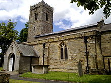
There is a Church dedicated to St Andrew which is Grade I listed. Above the entrance to the Church is a sundial that dates back to 1782.
Middleton Hall, next to the church, is a Grade II Listed house dating from the mid 18th century.
The village was part of the Ryedale district between 1974 and 2023. It is now administered by North Yorkshire Council.
References
- UK Census (2011). "Local Area Report – Middleton Parish (1170217271)". Nomis. Office for National Statistics. Retrieved 27 October 2018.
- Ordnance Survey: Landranger map sheet 94 Whitby & Esk Dale (Robin Hood's Bay) (Map). Ordnance Survey. 2012. ISBN 9780319228999.
- Historic England. "Church of St Andrew (Grade I) (1315705)". National Heritage List for England. Retrieved 27 October 2018.
- Historic England. "Middleton Hall (1149720)". National Heritage List for England. Retrieved 28 May 2020.
External links
[REDACTED] Media related to Middleton, Ryedale at Wikimedia Commons
This Ryedale location article is a stub. You can help Misplaced Pages by expanding it. |