Commune in Bourgogne-Franche-Comté, France
| Morbier | |
|---|---|
| Commune | |
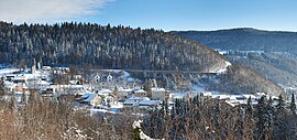
 A view of Morbier A view of Morbier | |
 Coat of arms Coat of arms | |
| Location of Morbier | |
  | |
| Coordinates: 46°32′15″N 6°01′03″E / 46.5375°N 6.0175°E / 46.5375; 6.0175 | |
| Country | France |
| Region | Bourgogne-Franche-Comté |
| Department | Jura |
| Arrondissement | Saint-Claude |
| Canton | Hauts de Bienne |
| Government | |
| • Mayor (2023–2026) | Philippe Huguenet |
| Area | 34.84 km (13.45 sq mi) |
| Population | 2,371 |
| • Density | 68/km (180/sq mi) |
| Time zone | UTC+01:00 (CET) |
| • Summer (DST) | UTC+02:00 (CEST) |
| INSEE/Postal code | 39367 /39400 |
| Elevation | 650–1,180 m (2,130–3,870 ft) |
| French Land Register data, which excludes lakes, ponds, glaciers > 1 km (0.386 sq mi or 247 acres) and river estuaries. | |
Morbier (French pronunciation: [mɔʁbje] ) is a commune in the Jura department in the Bourgogne-Franche-Comté region in Eastern France. From 1680 to 1920, Morbier was, with Morez, the centre of Comtoise clock production. It gave its name to the Morbier cheese, which is produced in a larger area in the Jura Mountains. It is part of Haut-Jura Regional Natural Park.
Population
In January 2007, Morbier absorbed the formerly independent commune of Tancua. Population data in the table below before 2009 refer to the commune of Morbier without Tancua.
|
| ||||||||||||||||||||||||||||||||||||||||||||||||||||||||||||||||||||||||||||||||||||||||||||||||||||||||||||||||||
| Source: EHESS and INSEE (2009–2020) | |||||||||||||||||||||||||||||||||||||||||||||||||||||||||||||||||||||||||||||||||||||||||||||||||||||||||||||||||||
See also
References
- "Répertoire national des élus: les maires" (in French). data.gouv.fr, Plateforme ouverte des données publiques françaises. 6 June 2023.
- "Populations de référence 2022" (in French). The National Institute of Statistics and Economic Studies. 19 December 2024.
- INSEE commune file
- Le fromage Morbier AOP
- Arrêté du 10 octobre 2006 portant modification aux circonscriptions administratives territoriales (fusion de communes), Légifrance.
- Des villages de Cassini aux communes d'aujourd'hui: Commune data sheet Morbier, EHESS (in French).
- Population en historique depuis 1968, INSEE