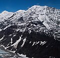
| Mount Church | |
|---|---|
 North aspect North aspect | |
| Highest point | |
| Elevation | 7,621 ft (2,323 m) |
| Prominence | 3,920 ft (1,190 m) |
| Coordinates | 62°52′45″N 150°41′00″W / 62.87917°N 150.68333°W / 62.87917; -150.68333 |
| Geography | |
 | |
| Interactive map of Mount Church | |
| Location | Matanuska-Susitna Borough Alaska, United States |
| Parent range | Alaska Range |
| Topo map | USGS Talkeetna D-2 |
Mount Church is a 7,621-foot (2,323 m) mountain in the Alaska Range, in Denali National Park and Preserve, overlooking Ruth Glacier. It is situated on the west side of the Ruth Gorge and 0.87 mi (1 km) southeast of Mount Grosvenor, which is the nearest higher neighbor. The mountain was named by famed explorer Dr. Frederick Cook who claimed the first ascent of Mount McKinley in 1906, but was later disproved.
Climate
Based on the Köppen climate classification, Mount Church is located in a subarctic climate zone with long, cold, snowy winters, and cool summers. Winter temperatures can drop below −20 °C with wind chill factors below −30 °C. The months May through June offer the most favorable weather for climbing or viewing.
Gallery
-
 South Aspect
-
 Left → Right: Mount Church, Mount Johnson, Mount Wake, and Mount Bradley
-
 Mt. Grosvenor (left) and Mt. Church (right) appear as snowy twin peaks in the center. South aspect.
See also
References
- ^ "Mount Church". Peakbagger.com. Retrieved April 11, 2013.
- ^ "Mount Church". Bivouac.com. Retrieved April 11, 2013.
- ^ "Mount Church". Geographic Names Information System. United States Geological Survey, United States Department of the Interior. Retrieved April 11, 2013.
- Americanalpineclub.org Four Ascents in the Great Gorge of the Ruth Glacier
- Peel, M. C.; Finlayson, B. L.; McMahon, T. A. (2007). "Updated world map of the Köppen−Geiger climate classification". Hydrol. Earth Syst. Sci. 11: 1633–1644. ISSN 1027-5606.
External links
- Weather forecast: Mount Church