Town in Western Australia
| Munglinup Western Australia | |||||||||||||||
|---|---|---|---|---|---|---|---|---|---|---|---|---|---|---|---|
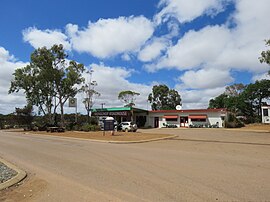
 The Munglinup Roadhouse in January 2024 The Munglinup Roadhouse in January 2024 | |||||||||||||||
 | |||||||||||||||
| Coordinates | 33°42′29″S 120°51′54″E / 33.70806°S 120.86500°E / -33.70806; 120.86500 | ||||||||||||||
| Population | 140 (SAL 2021) | ||||||||||||||
| Established | 1962 | ||||||||||||||
| Gazetted | 1962 | ||||||||||||||
| Postcode(s) | 6450 | ||||||||||||||
| Elevation | 87 m (285 ft) | ||||||||||||||
| Area | 3,044.7 km (1,175.6 sq mi) | ||||||||||||||
| Location | |||||||||||||||
| LGA(s) | Shire of Ravensthorpe | ||||||||||||||
| State electorate(s) | Roe | ||||||||||||||
| Federal division(s) | O'Connor | ||||||||||||||
| |||||||||||||||
Munglinup is a small town located in the Shire of Ravensthorpe in the Goldfields–Esperance region of Western Australia.
The town lies on the South Coast Highway between Ravensthorpe and Esperance and close to the Munglinup River. The river for most of its course defines the boundary of the Esperance and Ravensthorpe shires. At the Oldfield Estuary, the boundary goes to the eastern shore.
The word Munglinup is Noongar in origin and means where young people met their in-laws. The name first appears on maps made by the Dempster brothers, early settlers of the area in 1868.
The region was first opened up for farming in the late 1950s. By the early 1960s, the community asked for a townsite between Esperance and Ravensthorpe to be considered. The townsite was surveyed in 1961 and gazetted in 1962.
The surrounding areas produce wheat and other cereal crops. The town is a receival site for Cooperative Bulk Handling.
References
- Australian Bureau of Statistics (28 June 2022). "Munglinup (suburb and locality)". Australian Census 2021 QuickStats. Retrieved 28 June 2022.

- Karla Arnall (2 May 2016). "Discovering the land and its people through Noongar placenames". Australian Broadcasting Corporation. Retrieved 8 February 2018.
- ^ "New Townsite – Munglinup (per 1960/60)". Western Australia Government Gazette. 18 May 1962. p. 1962:1280.
- "History of country town names – M". Western Australian Land Information Authority. Archived from the original on 14 March 2022. Retrieved 10 October 2008.
- "CBH receival sites" (PDF). 2011. Archived from the original (PDF) on 18 March 2012. Retrieved 1 April 2013.
| Towns and localities in the Goldfields–Esperance region of Western Australia | |||||
|---|---|---|---|---|---|
| City of Kalgoorlie–Boulder |
| ||||
| Shire of Coolgardie | |||||
| Shire of Dundas | |||||
| Shire of Esperance |
| ||||
| Shire of Laverton | |||||
| Shire of Leonora | |||||
| Shire of Menzies | |||||
| Shire of Ngaanyatjarraku | |||||
| Shire of Ravensthorpe | |||||
| Shire of Wiluna | |||||
| |||||