| Municipality of Radeče Občina Radeče | |
|---|---|
| Municipality | |
 | |
 Flag Flag Coat of arms Coat of arms | |
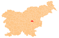
 Location of the Municipality of Radeče in Slovenia Location of the Municipality of Radeče in Slovenia | |
| Coordinates: 46°4′N 15°9′E / 46.067°N 15.150°E / 46.067; 15.150 | |
| Country | |
| Government | |
| • Mayor | Tomaž Režun |
| Area | |
| • Total | 52.0 km (20.1 sq mi) |
| Population | |
| • Total | 4,202 |
| • Density | 81/km (210/sq mi) |
| Time zone | UTC+01 (CET) |
| • Summer (DST) | UTC+02 (CEST) |
| Website | www |
The Municipality of Radeče (pronounced [ˈɾaːdɛtʃɛ] ; Slovene: Občina Radeče) is a municipality in central Slovenia. Its seat is the town of Radeče. The area is part of the traditional region of Lower Carniola. It is now included in the Lower Sava Statistical Region. Radeče became a municipality in 1994.
Settlements
In addition to the municipal seat of Radeče, the municipality also includes the following settlements:
- Brunk
- Brunška Gora
- Čimerno
- Dobrava
- Goreljce
- Hotemež
- Jagnjenica
- Jelovo
- Log pri Vrhovem
- Loška Gora
- Močilno
- Njivice
- Obrežje
- Počakovo
- Prapretno
- Rudna Vas
- Stari Dvor
- Svibno
- Vrhovo
- Zagrad
- Zavrate
- Žebnik
References
- ^ "Občina Radeče". Statistični urad Republike Slovenije. Retrieved April 3, 2020.
- Vzpostavitev lokalne samouprave v Republiki Sloveniji v številkah. Ljubljana: Statistični urad Republike Slovenije. 2007. p. 105. Retrieved April 3, 2020.
External links
- [REDACTED] Media related to Municipality of Radeče at Wikimedia Commons
- Municipality of Radeče on Geopedia
- Municipality of Radeče website
| Places adjacent to Municipality of Radeče | ||||||||||||||||
|---|---|---|---|---|---|---|---|---|---|---|---|---|---|---|---|---|
| ||||||||||||||||
| Municipality of Radeče | ||||||
|---|---|---|---|---|---|---|
| Settlements | Administrative seat: Radeče
|  | ||||
| Landmarks | ||||||
This article about the Municipality of Radeče in Slovenia is a stub. You can help Misplaced Pages by expanding it. |