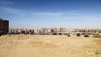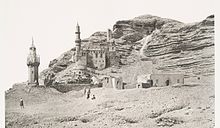

The Mokattam (Egyptian Arabic: المقطم [elmoˈʔɑtˤ.tˤɑm], also spelled Muqattam), also known as the Mukattam Mountain or Hills, is the name of an Eastern Desert plateau as well as the district built over it in the Southern Area of Cairo, Egypt.
Etymology
The Arabic name Mokattam means cut off or broken off and apparently refers to how the low range of hills is divided into three sections. Paul Casanova advocated the idea that it is a corruption of an older name Maqaduniya (Arabic: مقدونية), mentioned in Medieval Arabic sources, which he derives from Makhetow (Ancient Egyptian: Mḫꜣ.t-Tꜣ.wy, lit. 'Scales of the Two Lands'), one of the names of Memphis.
Landform
The highest segment is a low mountain landform called Moqattam Mountain. In the past the low mountain range was an important ancient Egyptian quarry site for limestone, used in the construction of temples and pyramids.
Settlement

The hills are in the region of ancient Fustat, the new capital founded by 'Amr ibn al-'As after the Muslim conquest of Egypt in 642 CE. The Zabbaleen people, who are an integral part of collecting and processing Cairo's municipal solid waste, live in Manshiyat Naser, Garbage City, at the foot of the Mokattam Hills.
EMAAR Misr, the Egyptian subsidiary of the Dubai-based real estate organization Emaar Properties built Uptown Cairo in Mokattam.
Municipal district and population
The Moqattam district lies in the Southern Area of Cairo, Egypt. In 2017, it had 224,138 residents in its 10 shiakhas:
| Shiakha | Code 2017 | Population |
|---|---|---|
| `Abd, al- | 011210 | 13,792 |
| Aḥyâ' | 011202 | 24,202 |
| Aṭlas C | 011209 | 39,191 |
| Jîza (Gizeh) | 011205 | 15,361 |
| Mukaṭṭam | 011201 | 19,426 |
| Naṣr al- | 011203 | 9,903 |
| Sab`în Faddân, al- | 011207 | 47,943 |
| Sharq li-l-Ta'mîn, al- | 011204 | 19,743 |
| Subḥî Ḥusayn | 011208 | 19,389 |
| Ṣa`îd, al- | 011206 | 15,188 |

Sports
In Mokkattam, like other places in Cairo, the locals support either Al Ahly SC or El Zamalek, yet Mokkattam itself has a football team that plays in the Egyptian third division called Misr Insurance (Masr Le El Tammeen). Moreover, the top division club Al Mokawloon Al Arab SC actually lies on the border of the Mokkattam mountain.

Simon the Tanner
Main article: Simon the Tanner § The miracle of moving the mountainMokattam is widely known in the Coptic Church, as it is believed that the mountain has moved up and down when the Coptic Pope Abraham of Alexandria, following the advice of Saint Simon the Tanner, performed a mass near it in order to prove to the Caliph that the Gospel is true when it says that "if one has faith like a grain of mustard one can move a mountain". The name "Broken-off Mountain" may be related to the fact that in the story the mountain breaks off from the underlying rock and rises up, before coming back down again.
See also
- Maqaduniya, a region of Medieval Egypt
- City of the Dead, Islamic necropolis and cemetery
- List of types of limestone, ancient Egyptians quarried limestone in the hills
- Sayyidah Zainab District
References
- "Southern Area". www.cairo.gov.eg. Archived from the original on 9 July 2022. Retrieved 2023-02-23.
- ^ Kamel, Seif. "Al Mokattam Mountain: On top of Cairo". Archived from the original on 2009-01-05. Retrieved 2009-02-05.
- Kebede-Francis, Enku (October 25, 2010). Global Health Disparities: Closing the Gap Through Good Governance. Jones & Bartlett Publishers. p. 320. ISBN 9781449619343.
- Johnson, Janet H., ed. (2001). The Demotic dictionary of the Oriental Institute of the University of Chicago. Chicago: The Oriental Institute. p. 216.
- Casanova, Paul. "Les noms coptes du Caire et localités voisines". BIFAO. 1: 195.
- "Cave Church". Archived from the original on 2007-10-28. Retrieved 2016-11-14.
{{cite web}}: CS1 maint: bot: original URL status unknown (link) - Egerton, Sir Philip de Malpas Grey (1854). "Palichthyologic Notes. No. 8. On some Ichthyolites from the Nummulitic Limestone of the Mokattam Hills, near Cairo". Quarterly Journal of the Geological Society. 10 (1–2): 374–378. doi:10.1144/GSL.JGS.1854.010.01-02.42. S2CID 130754356.
- Rappoport, S. The Founding of Fostât -The Project Gutenberg EBook of History Of Egypt From 330 B.C. To The Present Time, Volume 11 (of 12). Archived from the original on 14 November 2016. Retrieved 14 November 2016.
- Gauch, Sarah (January 6, 2003). "Egypt dumps 'garbage people'". The Christian Science Monitor. Archived from the original on March 22, 2009. Retrieved 2009-02-05.
- Central Agency for Public Mobilisation and Statistics (CAPMAS) (2017). "2017 Census for Population and Housing Conditions". CEDEJ-CAPMAS. Retrieved 2023-02-21.
- BBC Newshour The Angel of Garbage City, October 11, 2014, 20:00 UTC.
External links
30°01′N 31°18′E / 30.02°N 31.30°E / 30.02; 31.30
| Districts and suburbs of Greater Cairo | ||||||||||
|---|---|---|---|---|---|---|---|---|---|---|
| Cairo Governorate |
|   | ||||||||
| Giza Governorate |
| |||||||||
| Qalyubia Governorate |
| |||||||||