| Northeastern Congolian lowland forests | |
|---|---|
 Okapi Wildlife Reserve Okapi Wildlife Reserve | |
 Northeastern Congolian lowland forests Northeastern Congolian lowland forests | |
| Ecology | |
| Realm | Afrotropical |
| Biome | Tropical and subtropical moist broadleaf forests |
| Borders | List |
| Geography | |
| Area | 512,304 km (197,802 sq mi) |
| Countries | |
| Elevation | 600 m to 1,000 m |
| Coordinates | 2°12′N 25°42′E / 2.2°N 25.7°E / 2.2; 25.7 |
| Rivers | Bounded by Uele River, Congo River, Elila River, and Bomu River |
| Conservation | |
| Conservation status | vulnerable |
| Global 200 | yes |
| Protected | 54,712 km (11%) |
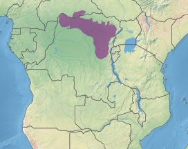
The Northeastern Congolian lowland forests (French: Forêts de plaine du nord-est du Congo) is a tropical moist broadleaf forest ecoregion that spans the Democratic Republic of the Congo and the Central African Republic.
Geography
The Northeastern Congolian lowland forests lie in the northeastern basin of the Congo River. The ecoregion is mostly in the Democratic Republic of the Congo, with a portion extending into the southern Central African Republic. It is the easternmost portion of the Guineo-Congolian region, a belt of tropical rain forests that extends through western and central Africa.
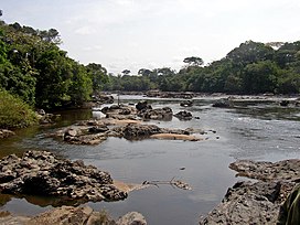
The Ituri Rainforest is in the ecoregion.
The ecoregion lies north and east of Congo River, and other rainforest ecoregions bound it on the west and southwest. It is bounded on the north by the Northern Congolian forest–savanna mosaic, and on the southwest by the Southern Congolian forest–savanna mosaic across the Congo River. The Albertine Rift mountains bound the Congo Basin on the east, and are home to the neighboring Albertine Rift montane forests ecoregion above 1500 meters elevation.
Climate
The climate is humid and tropical. Average annual rainfall ranges from 1,500 mm to 2,000 mm, and is generally lower in the east. There is a distinct dry season from January to March.
Flora
The predominant plant community is lowland moist forest. The forests are principally evergreen, with areas of semi-evergreen forest where some trees lose their leaves during the winter dry season. The forests are mostly a mix of species, although there are some single-species stands, notably Gilbertiodendron dewevrei.
Transitional submontane forest is found at the eastern edge of the ecoregion on the lower slopes of the Albertine Rift mountains, and drier transitional forest is found along the ecoregion's northern edge.
Fauna
16 mammals are endemic to the ecoregion, including the okapi (Okapia johnstoni), giant genet (Genetta victoriae), aquatic genet (Genetta piscivora), lesser forest shrew (Sylvisorex oriundus), African foggy shrew (Crocidura caliginea), fuscous shrew (Crocidura polia), owl-faced monkey (Cercopithecus hamlyni), and L'Hoest's monkey (Allochrocebus lhoesti). It is important habitat for the eastern lowland gorilla (Gorilla beringei graueri). Limited-range mammals include the pied bat (Glauconycteris superba) Allen's striped bat (Glauconycteris alboguttata), Misonne's soft-furred mouse (Praomys misonnei), and Verschuren's swamp rat (Congomys verschureni).
Endemic birds include Neumann's coucal (Centropus neumanni) and golden-naped weaver (Ploceus aureonucha). Nahan's francolin (Ptilopachus nahani), Ituri batis (Batis ituriensis), Turner's eremomela (Eremomela turneri), Congo peacock (Afropavo congensis), Sassi's greenbul (Phyllastrephus lorenzi), Bedford's paradise-flycatcher (Terpsiphone bedfordi), and Chapin's mountain-babbler (Turdoides chapini) are considered near-endemic.
There are seven endemic amphibians, including the olive shovelnose (Hemisus olivaceus), Kigulube reed frog (Hyperolius diaphanus), Kunungu reed frog (H. schoutendeni), Mertens' running frog (Kassina mertensi), Buta River frog (Phrynobatrachus gastoni), Christy's grassland frog (Ptychadena christyi), and Pangi Territory frog (Amietia chapini). There are five endemic reptiles, including the Zaire dwarf gecko.
People
The eastern edge of the ecoregion along the Albertine Rift is the most densely-populated. The central part of the ecoregion, including the Ituri Forest, is sparsely populated, and is home to the Mbuti people, an indigenous pygmy people who live by hunting and gathering in the forest.
Protected areas
A 2017 assessment found that 54,712 km, or 11%, of the ecoregion is in protected areas. 34% of the unprotected area is still forested. Protected areas include:
- Abumonbazi Nature Reserve
- Bangassou Forest Reserve
- Bili-Uere Hunting Reserve
- Bomu Wildlife Reserve
- Gangala-na-Bodio Hunting Reserve
- Kahuzi-Biega National Park
- Kisimba Ikobo Primate Nature Reserve
- Maika-Penge Hunting Reserve
- Maïko National Park
- Okapi Wildlife Reserve
- Rubi-Tele Hunting Reserve
- Tayna Nature Reserve
- Virunga National Park
- Yangambi Biosphere Reserve
External links
- "Northeastern Congolian lowland forests". Terrestrial Ecoregions. World Wildlife Fund.
References
- Blom, Allard; Schipper, Jan. "Western: Cameroon, Central African Republic, Gabon, and Republic of the Congo". World Wildlife Fund. Archived from the original on 2017-09-03. Retrieved 2017-08-30.
- Eric Dinerstein, David Olson, et al. (2017). An Ecoregion-Based Approach to Protecting Half the Terrestrial Realm, BioScience, Volume 67, Issue 6, June 2017, Pages 534–545; Supplemental material 2 table S1b.
- "Map of Ecoregions 2017". Resolve. Retrieved August 20, 2021.
- ^ "Northeastern Congolian lowland forests". Digital Observatory for Protected Areas. Retrieved 9 May 2022.
- "Northeastern Congolian lowland forests". The Encyclopedia of Earth. Retrieved August 20, 2021.
- ^ "Northeastern Congolian lowland forests". Terrestrial Ecoregions. World Wildlife Fund.
- Eric Dinerstein, David Olson, et al. (2017). An Ecoregion-Based Approach to Protecting Half the Terrestrial Realm, BioScience, Volume 67, Issue 6, June 2017, Pages 534–545; Supplemental material 2 table S1b.
- Northeastern Congolian lowland forests
- Afrotropical ecoregions
- Congolian forests
- Ecoregions of the Central African Republic
- Ecoregions of the Democratic Republic of the Congo
- Flora of West-Central Tropical Africa
- Flora of the Central African Republic
- Flora of the Democratic Republic of the Congo
- Rainforests of Africa
- Tropical and subtropical moist broadleaf forests