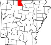
Census-designated place in Arkansas, United States
| Oakland, Arkansas | |
|---|---|
| Census-designated place | |
  | |
| Coordinates: 36°27′38″N 92°34′18″W / 36.46056°N 92.57167°W / 36.46056; -92.57167 | |
| Country | United States |
| State | Arkansas |
| County | Marion |
| Area | |
| • Total | 1.19 sq mi (3.1 km) |
| • Land | 1.19 sq mi (3.1 km) |
| • Water | 0.0 sq mi (0 km) |
| Elevation | 1,043 ft (318 m) |
| Population | |
| • Total | 72 |
| Time zone | UTC-6 (Central (CST)) |
| • Summer (DST) | UTC-5 (CDT) |
| ZIP code | 72661 |
| Area code | 870 |
| GNIS feature ID | 2805669 |
| FIPS code | 05-51110 |
Oakland is an unincorporated community and census-designated place (CDP) in northeastern Marion County, Arkansas, United States. Oakland, located on Arkansas Highway 202, is 20 miles (32 km) by road northwest of Mountain Home. Oakland has a post office with ZIP code 72661. The Oakland Campground on Bull Shoals Lake lies about three miles to the west at the end of Route 202. It was first listed as a CDP in the 2020 census, with a population of 72.
Education
It is in the Mountain Home School District. The Oakland School District consolidated into the Mountain Home district on July 1, 1986.
Demographics
| Census | Pop. | Note | %± |
|---|---|---|---|
| 2020 | 72 | — | |
| U.S. Decennial Census 2020 | |||
2020 census
| Race / Ethnicity | Pop 2020 | % 2020 |
|---|---|---|
| White alone (NH) | 71 | 98.61% |
| Black or African American alone (NH) | 0 | 0.00% |
| Native American or Alaska Native alone (NH) | 0 | 0.00% |
| Asian alone (NH) | 1 | 1.39% |
| Pacific Islander alone (NH) | 0 | 0.00% |
| Some Other Race alone (NH) | 0 | 0.00% |
| Mixed Race/Multi-Racial (NH) | 0 | 0.00% |
| Hispanic or Latino (any race) | 0 | 0.00% |
| Total | 72 | 100.00% |
References
- "2021 U.S. Gazetteer Files: Arkansas". United States Census Bureau. Retrieved May 31, 2022.
- ^ U.S. Geological Survey Geographic Names Information System: Oakland, Arkansas
- ^ "P1. Race – Oakland CDP, Arkansas: 2020 DEC Redistricting Data (PL 94-171)". U.S. Census Bureau. Retrieved May 31, 2022.
- ZIP Code Lookup
- Arkansas Atlas & Gazetteer, Delorme, 2nd ed., 2004, p. 25 ISBN 0-89933-345-1
- 2020 CENSUS - SCHOOL DISTRICT REFERENCE MAP: Marion County, AR (PDF) (Map). U.S. Census Bureau. Retrieved January 10, 2025. - Text list
- "ConsolidationAnnex_from_1983.xls Archived 2015-09-12 at the Wayback Machine." Arkansas Department of Education. Retrieved on October 13, 2017.
- "Decennial Census of Population and Housing by Decades". US Census Bureau.
- ^ "P2 HISPANIC OR LATINO, AND NOT HISPANIC OR LATINO BY RACE – 2020: DEC Redistricting Data (PL 94-171) – Oakland CDP, Arkansas". United States Census Bureau.
| Municipalities and communities of Marion County, Arkansas, United States | ||
|---|---|---|
| County seat: Yellville | ||
| Cities |  | |
| Town | ||
| CDP | ||
| Other unincorporated communities | ||
This article about a location in Marion County, Arkansas is a stub. You can help Misplaced Pages by expanding it. |