| This article needs additional citations for verification. Please help improve this article by adding citations to reliable sources. Unsourced material may be challenged and removed. Find sources: "Ocean data acquisition system" – news · newspapers · books · scholar · JSTOR (September 2016) (Learn how and when to remove this message) |
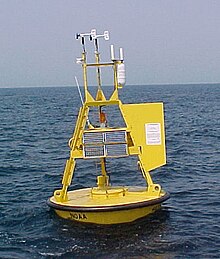
An ocean data acquisition system (ODAS) is a set of instruments deployed at sea to collect as much meteorological and oceanographic data as possible. With their sensors, these systems deliver data both on the state of the ocean itself and the surrounding lower atmosphere. The use of microelectronics and technologies with efficient energy consumption allows to increase the types and numbers of sensor deployed on a single device.
Definition
According to Intergovernmental Oceanographic Commission and World Meteorological Organization (WMO), "ODAS means a structure, platform, installation, buoy, or other device, not being a ship, together with its appurtenant equipment, deployed at sea essentially for the purpose of collecting, storing or transmitting samples or data relating to the marine environment or the atmosphere or the uses thereof."
Use
Each hour, the data gathered by the system is transferred to the WMO's Global Telecommunications System by a geostationary satellite after having gone through a number of quality checks. Real-time data with information on the maritime environment can then be used for forecasts of physical states like weather, ocean currents or wave conditions which, in turn, may serve to warn seafarers of unfavourable conditions in the area.
ODAS types

ODAS can be mounted on the following structures:
ODAS buoys are not navigational aids but have been included into the IALA Maritime Buoyage System. The structures have a fixed geographical position.
Data
Data gathered by an ODAS may include the following parameters:
- Air temperature
- Atmospheric pressure at sea level
- Wind direction
- Wind speed including gusts
- Sea state
- Wave height
- Sea surface temperature
Disadvantages
- ODAS buoys are expensive to obtain and need to be deployed by specialised vessels.
References
- Meinl, A. (1996). Guide to moored Buoys and other Ocean Data Acquisition Systems (PDF). DBCP Technical Document No. 8. Intergovernmental Oceanographic Commission, World Meteorological Organization. p. 3.
- Skey, S. G. P.; Miles, M. D. "Advances in Buoy Technology for Wind/Wave Data Collection and Analysis" (PDF). Axys Technologies. Retrieved 30 September 2016.
- Platform Metadata Catalogue: ODAS Metadata. Second session. Joint WMO/IOC Technical Commission for Oceanography and Marine Meteorology (JCOMM) Expert Team on Marine Cimatology. 26–27 March 2007.
- "ODAS buoy". International Dictionary of Marine Aids to Navigation. International Association of Marine Aids to Navigation and Lighthouse Authorities. 15 February 2009. Retrieved 30 September 2016.