United States historic place
| Ouray Historic District | |
| U.S. National Register of Historic Places | |
 | |
 | |
| Location | U.S. Highway 550, Ouray, Colorado |
|---|---|
| Coordinates | 38°01′22″N 107°40′24″W / 38.0228°N 107.6733°W / 38.0228; -107.6733 |
| Area | 114 acres (0.46 km) |
| Architectural style | Italianate; Late Victorian |
| NRHP reference No. | 83003537 |
| Added to NRHP | October 6, 1983 |
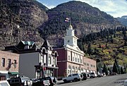
The Ouray Historic District, in Ouray, Colorado, is a 114-acre (0.46 km) historic district which was listed on the National Register of Historic Places in 1983. Many of the commercial buildings are Italianate in style; many residences are Victorian.
Its 270 contributing buildings include government and commercial buildings:
- Ouray County Courthouse (1881)
- Beaumont Hotel (1886)
- Wright Opera House (1888), with an elaborate Mesker Brothers cast-iron facade
- Duckett's Market
- St. Elmo Hotel (1899)
- Story Block (1892)
Many of the commercial buildings are along Ouray's Main Street, also known as Third Street, which is U.S. Highway 550.
Residences include:
- Hurlbutt House (1888)
The historic district encompasses almost all of the original townsite. Its boundary is an irregular pattern extending to and including the Ouray hot springs pool on the north, to the west side of Oak Street on the west side of the Uncompahgre River on the west, to the south side of Third Avenue on the south, and to the east side of 6th Street on the east.
Photos-
 Main Street at night, with Beaumont Hotel in foreground
-
 Ouray County Courthouse (1881)
-
First Presbyterian Church, oldest church in Ouray
-
 City hall and fire station
-
 General view from northeast
-
General view from south
References
- ^ "National Register Information System". National Register of Historic Places. National Park Service. November 2, 2013.
- ^ "Ouray Historic District". History Colorado. Includes map with outline of district.
- ^ Martha Sullenberger; Roger Henn (February 1983). "National Register of Historic Places Inventory/Nomination: Ouray Historic District". National Park Service. Retrieved February 2, 2022. With accompanying 97 photos PDF includes text narration of boundaries but not a map that is referenced and was included in the original submission.
External links
- [REDACTED] Media related to Ouray Historic District at Wikimedia Commons
| U.S. National Register of Historic Places | |
|---|---|
| Topics | |
| Lists by state |
|
| Lists by insular areas | |
| Lists by associated state | |
| Other areas | |
| Related | |
This article about a property in Colorado on the National Register of Historic Places is a stub. You can help Misplaced Pages by expanding it. |