| San Giacomo | |
|---|---|
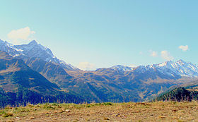
 San Giacomo Pass (center) from the northern side San Giacomo Pass (center) from the northern side | |
| Elevation | 2,307 m (7,569 ft) |
| Traversed by | Trail |
| Location | Piedmont, Italy Ticino, Switzerland |
| Range | Lepontine Alps |
| Coordinates | 46°27′33″N 8°27′09″E / 46.45917°N 8.45250°E / 46.45917; 8.45250 |
 | |
The San Giacomo Pass (Italian: Passo San Giacomo) is an Alpine pass connecting Switzerland and Italy. It connects Bedretto on its northern side (valley of Leventina) to Formazza on its southern side.
The pass is located between the Helgenhorn (west) and the Marchhorn (east).
It saw most use in the 14th and 15th century, when muleteers would transport wares over it, and remained in extended use until the opening of the Gotthard railway in 1882.
References
- "Maps of Switzerland - Swiss Confederation - map.geo.admin.ch". map.geo.admin.ch. swisstopo. Retrieved 21 January 2025.
- ^ Fransioli, Mario. "San Giacomo, Passo di". hls-dhs-dss.ch (in German). Historical Dictionary of Switzerland. Retrieved 21 January 2025.
External links
This Ticino location article is a stub. You can help Misplaced Pages by expanding it. |
This article on a location in the Province of Verbano-Cusio-Ossola is a stub. You can help Misplaced Pages by expanding it. |