Unincorporated community in Pennsylvania, United States
| Paupack, Pennsylvania | |
|---|---|
| Unincorporated community | |
 Paupack School Paupack School | |
 | |
| Coordinates: 41°23′46″N 75°11′47″W / 41.39611°N 75.19639°W / 41.39611; -75.19639 | |
| Country | United States |
| State | Pennsylvania |
| County | Pike |
| Elevation | 1,565 ft (477 m) |
| Time zone | UTC-5 (Eastern (EST)) |
| • Summer (DST) | UTC-4 (EDT) |
| ZIP code | 18451 |
| Area code(s) | 272 & 570 |
| GNIS feature ID | 1199282 |
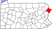
Paupack is an unincorporated community in Pike County, Pennsylvania, United States. The community is 5.5 miles (8.9 km) south of Hawley. Paupack has a post office with ZIP code 18451, which opened on October 19, 1900. The community derives its name from Wallenpaupack Creek. The area was originally served by Paupack Consolidated School, which dates back to 1925 and is on the National Register of Historic Places.
References
- ^ "Paupack". Geographic Names Information System. United States Geological Survey, United States Department of the Interior.
- United States Postal Service. "USPS - Look Up a ZIP Code". Retrieved August 13, 2017.
- "Postmaster Finder - Post Offices by ZIP Code". United States Postal Service. Retrieved August 13, 2017.
- Espenshade, Abraham Howry (1925). Pennsylvania Place Names. Evangelical Press. p. 286. ISBN 978-0-8063-0416-8.
- "NPGallery Digital Asset Management System". NPGallery Digital Asset Management System.
| Municipalities and communities of Pike County, Pennsylvania, United States | ||
|---|---|---|
| County seat: Milford | ||
| Boroughs |  | |
| Townships | ||
| CDPs | ||
| Unincorporated communities | ||
| Footnotes | ‡This populated place also has portions in an adjacent county or counties. | |
This Pike County, Pennsylvania state location article is a stub. You can help Misplaced Pages by expanding it. |