| Phuparash Peak | |
|---|---|
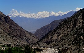
 View of Phuparash among other mountain tops View of Phuparash among other mountain tops | |
| Highest point | |
| Elevation | 6,574 m (21,568 ft) |
| Coordinates | 36°3′0.68″N 74°49′30.03″E / 36.0501889°N 74.8250083°E / 36.0501889; 74.8250083 |
| Geography | |
| Location | Hispar, Pakistan |
| Parent range | Karakoram |
Phuparash Peak is a mountain in Hispar Valley in the Gilgit District, Gilgit–Baltistan, Pakistan. It lies east of Miar Peak (6,824 m). The Phuparash and Miar glaciers are nearby.
The peak is visible when trekking to Rush Lake.
See also
References
- Awan, Naseer Ullah (1990). The Unique Mountains. Alpine Club of Pakistan. p. 231.
- "Landscape of Pakistan". Embassy of Pakistan. Copenhagen, Denmark. Retrieved 24 November 2024.
External links
This Gilgit-Baltistan location article is a stub. You can help Misplaced Pages by expanding it. |