| Pico Jano | |
|---|---|
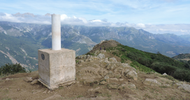
 Trig point on the summit Trig point on the summit | |
| Highest point | |
| Elevation | 1,446 m (4,744 ft) |
| Prominence | 350 m (1,150 ft) |
| Isolation | 8.39 km (5.21 mi) |
| Coordinates | 43°07′00″N 4°42′01″W / 43.11655°N 4.70041°W / 43.11655; -4.70041 |
| Geography | |
 | |
| Location | Cantabria, Spain |
| Parent range | Cantabrian Mountains |
| Climbing | |
| Easiest route | footpath from Dobarganes |
Pico Jano is a mountain of Cantabria (northern Spain).
Geography

The mountain is part of the range dividing the valleys of rivers Deva and Quiviesa. Located between the municipalities of Camaleño and Vega de Liébana, both in Liébana, its highest point is occupied by a pillar used as trig point, whose base is at 1,446-metre (4,744 ft) m. The mountain must not be confused with another Pico Jano close to Bárcena de Pie de Concha (1,289.7-metre (4,231 ft)).
Access to the summit
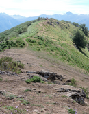
An easy and well waymarked route to Pico Jano starts from Dobarganes, a village of Vega de Liébana municipality. Its length is about 4 km. The summit can also be reached by mountain bike. Pico Jano offers views of Picos de Europa.
References
- VV.AA. (1990). El Bosque en Cantabria (in Spanish). Ed. Universidad de Cantabria. p. 21. ISBN 9788487412165. Retrieved 2017-01-20.
- "Jano, Pico (1.446 m)" (in Spanish). Retrieved 2017-01-20.
- VV.AA. (2008). Liébana y letras (in Spanish). Ed. Universidad de Cantabria. p. 12. ISBN 9788481025095. Retrieved 2017-01-20.
- Instituto Geográfico Nacional. "Reseña Vértice Geodésico" (PDF) (in Spanish). Retrieved 2017-01-20.
- Río Calonge, Roberto. "Dobarganes-Pico Jano-Dobarganes" (in Spanish). Retrieved 2017-01-20.
- "Pico Jano" (in Spanish). 2012-03-19. Retrieved 2017-01-20.
- "Ocio Jano, La Liebana" (in Spanish). Retrieved 2017-01-20.
External links
[REDACTED] Media related to Pico Jano at Wikimedia Commons
Categories: