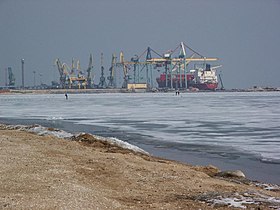
| Port of Mariupol | |
|---|---|
 Port of Mariupol, 2006 Port of Mariupol, 2006 | |
| Click on the map for a fullscreen view | |
| Location | |
| Country | |
| Location | Mariupol, Donetsk Oblast |
| Details | |
| Opened | September 2, 1889 |
| Head of the seaport administration | Sergey Vladimirovich Gusakov |
| Statistics | |
| Website Port Administration Site | |
The Port of Mariupol or Mariupol Sea Port (Ukrainian: Маріупольський морський порт) is located in Mariupol, Ukraine in the Taganrog Bay, Sea of Azov. The port is governed by the port authority managed by Ukrainian Sea Ports Authority. As of June 2022, it is occupied by Russian armed forces.
The berthing line of the seaport is 3.9 km (22 berths), with depths down to 9.75 meters. The port is served by one port railway station "Mariupol-Port." The total length of the railways of the port is 27,1 km. Highways are adjacent to the port.
The cargo turnover of Mariupol seaport in 2016 amounted to 7.6 million tons, the capacity of Mariupol seaport reaches 18.8 million tons per year.
The port has the largest repair facility of its class on the Sea of Azov.
History
The birth of the port of Mariupol was a logical continuation of rapid development of the industrial Russian South in the second half of 19th century. The shallow wharf in the mouth of the Kalmius River did not meet the development requirements of the fleet along with those of the mining and metallurgical industry of Donets basin (Donbas).
In 1886 construction began for a deepwater port in Mariupol, near Zintseva balka (locality).
The construction was planned for five years, but was finished in three under pressure from industrialists.
On 2 September [O.S. 21 August] 1889, 18 railcars carrying coal (about 2,000 poods) were brought on the port's embankment.
After a prayer in the presence of the Russian Minister of Railways and the Mariupol city governor Kharazhaev, there began the first loading onto a steamship of the Russian Society of Shipping and Trade "Medveditsa", which on 3 September [O.S. 22 August] 1889 left for its destination.
This date is considered the start date of the port's operation. The port had huge significance for the development of industry in the region and the whole country. In the period 1867–1904, the Port of Mariupol was third in Russia among non-military ports by volume of assignments.
During the Russian Invasion of Ukraine, Russian forces took and occupied Mariupol.
On 26 May 2022, following closure during the Siege of Mariupol, Russia reopened the port to commercial vessels following naval mine removal. TASS stated that the port was operating at full capacity by July 2022. The first bulk carrier, carrying grain, was reportedly loaded by the Donetsk People's Republic in 2023 to be exported. In June 2024, the city's exiled mayor, Vadym Boychenko, said that a Russian tanker had entered the port for the first time since its capture, and that it was being used for military use.
Gallery
-
 Photo to the article "Mariupol port" from Sytin's Military Encyclopedia (St. Petersburg, 1911–1915).
-
Seaport terminal in 2010.
-
 Port of Mariupol, January 2020.
See also
References
- "В.о начальника Маріупольської філії ДП "АМПУ" призачено Сергія Гусакова". Retrieved 28 April 2020.
- Konstantinova Victoria, Lyman Igor, Ignatova Anastasiya. "European Vector of the Northern Azov in the Imperial Period: British Consular Reports about Italian Shipping". Berdyansk: Tkachuk O.V., 2016. p. 184
- "Russia says civil vessels may use Mariupol port, mine danger lifted". Reuters. 26 May 2022. Retrieved 27 May 2022.
- "Mariupol port operating at full capacity, TASS quotes officials". Rueters. 6 July 2022.
- Dixon, Gary (17 June 2024). "'Supply base': Russian tanker spotted in Ukraine's Mariupol port for first time". TradeWinds.
External links
- Port of Mariupol Authority
- Official website of State Stevedore Port Operator
- Port of Mariupol at the Ministry of Infrastructure
47°03′21″N 37°30′18″E / 47.0558333433°N 37.50500001°E / 47.0558333433; 37.50500001
| Black Sea | ||
|---|---|---|
| Azov Sea | ||
| River | ||
| Ferry | ||
| South China Sea (owned) | ||
| ||
This Ukrainian corporation or company article is a stub. You can help Misplaced Pages by expanding it. |
This Soviet Union–related article is a stub. You can help Misplaced Pages by expanding it. |
This Ukrainian history–related article is a stub. You can help Misplaced Pages by expanding it. |