| Politics of Tajikistan |
|---|
 |
|
|
| Constitution |
| Government |
| Legislature |
Elections
|
| Administrative divisions |
Foreign relations
|
|
|
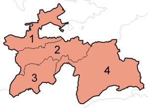
Administratively, Tajikistan is divided into:
- one autonomous region (Russian: автономная область; Tajik: вилояти мухтор, romanized: viloyati mukhtor)
- two regions (Tajik: вилоятҳо, romanized: viloyatho, Persian: ولایتها), sing. viloyat, Persian: ولایت, Russian: область/вилоят, romanized: oblast)
- the districts under republic subordination
- the capital city, Dushanbe.

List of regions
| No. | Name | Russian | Tajik | ISO | Capital | Area (km) | Pop. (2000) | Pop. (2010) | Pop. (2019) |
|---|---|---|---|---|---|---|---|---|---|
| 1 | Sughd Region | Согдийская область Sogdijskaya oblast |
Вилояти Суғд Viloyati Sughd |
TJ-SU | Khujand | 25,400 | 1,871,979 | 2,233,550 | 2,658,400 |
| 2 | Districts under Republic Subordination | Районы республиканского подчинения Rajoni respublikanskovo podchineniya |
Ноҳияҳои тобеи ҷумҳурӣ Nohiyahoi tobei jumhurī |
TJ-RA | Dushanbe | 28,600 | 1,337,479 | 1,722,908 | 2,120,000 |
| 3 | Khatlon Region | Хатлонская область Khatlonskaya oblast' |
Вилояти Хатлон Viloyati Khatlon |
TJ-KT | Bokhtar | 24,800 | 2,150,136 | 2,677,251 | 3,274,900 |
| 4 | Gorno-Badakhshan Autonomous Region | Горно-Бадахшанская автономная область Gorno-Badakhshanskaya avtonomnaya oblast' |
Вилояти Мухтори Кӯҳистони Бадахшон Viloyati Mukhtori Kūhistoni Badakhshon |
TJ-GB | Khorugh | 64,200 | 206,004 | 205,949 | 226,900 |
| – | Dushanbe | Душанбе Dushanbe |
Душанбе Dushanbe |
TJ-DU | Dushanbe | 124.6 | 561,895 | 724,844 | 846,400 |
- Notes
- The direct translation from Tajik is Kuhistoni Badakhshon Autonoumous Region, but the name translated from Russian is more commonly used in English.
Administrative divisions
Each region is divided into districts (Tajik: ноҳия, nohiya or Russian: район, rayon), which are further subdivided into municipal units: either as urban municipalities called either as cities (Tajik: шаҳр, romanized: şahr, "cities") or towns (Tajik: шаҳрак, romanized: şahrak, "towns"), or as rural municipalities called jamoats (Tajik: ҷамоати деҳот, romanized: jamoati dehot, "village communes"), which in turn are further subdivided into villages/settlements (Tajik: деҳа or қишлоқ, romanized: deha or qyshloq, "villages/hamlets").
As of 2020, Tajikistan has a total of 47 (not including 4 districts of the capital city Dushanbe) districts; prior to 2017 it had about 58.
| Type | Native name | Level | Number |
|---|---|---|---|
| Districts | ноҳия nohiya |
2 | 47 |
| Cities | шаҳр shahr |
2 | 18 |
| Jamoats | 3 | 368 | |
| Towns | шаҳрак shahrak |
3 | 65 |
See also
- Districts of Tajikistan
- List of regions of Tajikistan by Human Development Index
- ISO 3166-2:TJ
- Yagnob Valley
References
- "Changes in the number and distribution of the population of the Republic of Tajikistan between the censuses of 2000 and 2010" (PDF) (in Russian). Tajstat. Archived from the original (PDF) on 2014-01-04. Retrieved 12 September 2014.
- "Tajikistan: Provinces and Major Cities". City Population. Retrieved 1 February 2020.
- "Population of the Republic of Tajikistan as of 1 January 2020" (PDF) (in Russian). Statistics office of Tajikistan. p. 13. Retrieved 2 October 2020.
| Regions of Tajikistan | |||
|---|---|---|---|
| Tajikistan articles | |||||||
|---|---|---|---|---|---|---|---|
| History |  | ||||||
| Geography |
| ||||||
| Politics | |||||||
| Economy | |||||||
| Society |
| ||||||
| Articles on first-level administrative divisions of Asian countries | |
|---|---|
| Sovereign states |
|
| States with limited recognition | |
Table of administrative divisions by country
| |