| Psara Ψαρά | |
|---|---|
| Municipality | |
 Psara, Black Ridge Psara, Black Ridge | |
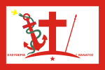
 Flag Flag | |
  | |
| Coordinates: 38°33′N 25°34′E / 38.550°N 25.567°E / 38.550; 25.567 | |
| Country | Greece |
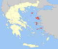
| Administrative region | North Aegean |
| Regional unit | Chios |
| Area | |
| • Municipality | 44.511 km (17.186 sq mi) |
| Highest elevation | 512 m (1,680 ft) |
| Lowest elevation | 0 m (0 ft) |
| Population | |
| • Municipality | 420 |
| • Density | 9.4/km (24/sq mi) |
| Time zone | UTC+2 (EET) |
| • Summer (DST) | UTC+3 (EEST) |
| Postal code | 82x xx |
| Area code(s) | 22740 |
| Vehicle registration | ΧΙ |
| Website | www.dimospsaron.gr |
Psara (Greek: Ψαρά, Psará, [psaˈra]; known in ancient times as Ψύρα/Ψυρίη, Psyra/Psyriē) is a Greek island in the Aegean Sea. Together with the small island of Antipsara (population 4) it forms the municipality of Psara. It is part of the Chios regional unit, which is part of the North Aegean region. The only town of the island and seat of the municipality is also called Psara.
Psara had 420 inhabitants according to the 2021 census. It has a small port linking to the island of Chios and other parts of Greece.
In the Psara massacre on the island, thousands of Greeks were massacred by Ottoman troops during the Greek War of Independence in 1824.
Geography

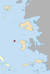
Psara lies 81 km (50 mi) northwest of Chios, 22 km (14 miles) from the northwestern point of the island of Chios and 150 km (93 mi) east-northeast of Athens. The length and width of the island are about 7 by 8 km (4 by 5 mi) and the area is 43 km (17 sq mi). The highest point on the island is "Profitis Ilias" (512 m (1,680 ft)). The municipality has total area of 44.511 km (17.186 sq mi).
Flag
The modern flag of Psara is based largely on the island's famous revolutionary flag created by Psariot locals in 1824. The original flag, carried during the War of Independence by Psariot ships, was made of white cloth bordered with red. It bore the symbols of Filiki Eteria in red (a large cross atop a crescent, a spear, and an anchor). A snake was wrapped around the anchor, often depicted with a bird flying near its mouth. On either side of the Filiki Eteria symbols, in red capital letters, were the words ΕΛΕΥΘΕΡΙΑ Η ΘΑΝΑΤΟΣ (FREEDOM OR DEATH) and in some cases, the island's name, spelled ΨΑ–ΡΑ or ΨΑΡ–ΡΑ. An original 1824 flag of Psara is preserved at the National Historical Museum of Greece.

The flag of Psara currently in use has a very similar design but omits the island's name and bears a star below the crescent.
History
Psara has been inhabited since the Mycenaean period, its inhabitants relying on the sea to make a living as the island is treeless and rocky with little shrubbery.
Homer, Strabo, Cratinus, Suda and Stephanus of Byzantium referred to the island as Psyra (Ancient Greek: Ψυρά and Ψύρα) and Psyrian (Ancient Greek: Ψυρίαν). The island had a city also called Psyra.
The islanders' sole source of livelihood has always been fishing, mainly for the locally abundant slipper lobsters, and shipping, with some tourist development in recent years.
The Greek ancient proverb Psyra celebrating Dionysos (Ancient Greek: Ψύρα τὸν Διόνυσον ἄγοντες) originated from the fact that Psyra was a poor and small island which could not produce its own wine, and was used in reference to people who were reclining at a symposium but not drinking. Another ancient Greek proverb, You regard Sparta as Psyra (Ancient Greek: Ψύρα τε τὴν Σπάρτην ἄγεις), also expressed the poverty of the island.
During the Middle Ages Psara had a very small population, which abandoned the island for Chios after the Fall of Constantinople. Between the 14th and second half of the 15th century, a small group of Albanians settled on the island and developed an Arvanite community, but it was quickly assimilated into the local Greek population. In the 16th century, under the Ottoman rule, the Psariots who had previously left, returned to their homeland along with other settlers and established a settlement around the Palaiokastro fort which they repaired. They turned to trade, amassing great profits. By the beginning of the 19th century the Psariots had the third largest trade fleet in Greece after Hydra and Spetses, numbering some 45 ships.
Destruction
Main article: Destruction of Psara
Psara joined the Greek War of Independence on April 10, 1821. Future Prime Minister Konstantinos Kanaris, Dimitrios Papanikolis, Andreas Pipinos and Nikolis Apostolis distinguished themselves as naval leaders, using fire ships to combat the more powerful Ottoman Navy. Psara's native population of 7,500 people was further augmented by 23,000 refugees from Thessaly, Macedonia, Chios, Moschonisia and Kydonies.
On July 3 (June 21 O.S.), 1824, the island was invaded by the Turks. The resistance of the Psariots ended the next day with a last stand at the town's old fort of Palaiokastro (alternative name Mavri Rachi, literally "black ridge"). Hundreds of soldiers and also women and children had taken refuge there when an Ottoman force of 2,000 stormed the fort. The refugees first threw a white flag with the words "Ἐλευθερία ἤ Θάνατος" ("Eleftheria i Thanatos", "Freedom or Death"). Then, the moment the Turks entered the fort, the local Antonios Vratsanos lit a fuse to the gunpowder stock, in an explosion that killed the town's inhabitants along with their enemies — thus remaining faithful to their flag to their death. A French officer who heard and saw the explosion compared it to a volcanic eruption of Vesuvius.
A part of the population managed to flee the island, but those who did not were either sold into slavery or killed. As a result of the invasion, thousands of Greeks met a tragic fate. The island was deserted and surviving islanders were scattered through what is now Southern Greece. Theophilos Kairis, a priest and scholar, took on many of the orphaned children and developed the famous school the Orphanotropheio of Theophilos Kairis. Psara remained in the hands of the Ottomans until it was recaptured by the Greek navy on 21 October 1912 during the First Balkan War.
Historical population

A native of Psara is known in English as a Psariot or a Psarian.
| Year | Population | Difference |
|---|---|---|
| 1824 | 7,000 | |
| 1951 | 700 | |
| 1961 | 576 | - 17.7% |
| 1971 | 487 | - 15.5% |
| 1981 | 460 | - 5.5% |
| 1991 | 438 | - 4.8% |
| 2001 | 422 | - 3.7% |
| 2011 | 446 | + 5.7% |
| 2021 | 420 | - 5.8% |
Notable people

Notable natives and inhabitants of the island include:
- Ioannis Varvakis (1745–1825), admiral, caviar merchant and benefactor.
- Nikolis Apostolis (1770–1827), admiral.
- Dimitrios Papanikolis (1790–1855), admiral.
- Konstantinos Kanaris (1793/1795–1877), admiral and politician, Prime Minister of Greece.
- Garafilia Mohalbi (1817–1830), Greek-American refugee and former slave.
- George Sirian (1818–1891), United States Navy officer.
See also
References
- "Αποτελέσματα Απογραφής Πληθυσμού - Κατοικιών 2021, Μόνιμος Πληθυσμός κατά οικισμό" [Results of the 2021 Population - Housing Census, Permanent population by settlement] (in Greek). Hellenic Statistical Authority. 29 March 2024.
- "ΦΕΚ B 1292/2010, Kallikratis reform municipalities" (in Greek). Government Gazette.
- "Population & housing census 2001 (incl. area and average elevation)" (PDF) (in Greek). National Statistical Service of Greece.
- "Η Ελληνική Σημάια", (The Greek flag) - Hellenic Army General Staff, Page 11, Image 14: Archived 2016-03-27 at the Wayback Machine
- ^ Σημαία των Ψαρών, Επανάσταση 1821 (Αρ. κατ. 1752) [Flag of Psara, Revolution of 1821 (Catalogue Num. 1752)]. Εθνικό Ιστορικό Μουσείο (in Greek). Archived from the original on 2014-09-25. Retrieved 2020-05-01.
- Murgescu, Mirela-Luminita; Koulouri, Christina, eds. (2005). "National Ideologies". Nations and States in Southeast Europe (PDF). Thessaloniki: Center for Democracy and Reconciliation in South-Eastern Europe. p. 99. ISBN 960-86857-4-5. Archived from the original (PDF) on 2010-05-09.
- Sache, Ivan (2015-08-10). "Psara (Municipality, Greece)". www.crwflags.com. Retrieved 2020-05-02.
- Homer, Odyssey, §3.148
- ^ Strabo, Geography, §14.1.35
- ^ Suda Encyclopedia, §psi.155
- ^ Stephanus of Byzantium, Ethnica, §Ps703.2
- Agelarakis A., "Report on the Main Burial of the Mycenaean Human Skeletal Remains excavated from Archontiki Site, Psara, Greece", OSSA 13 (1986-87): 3-11.
- Pliny. Naturalis Historia. Vol. 5.36.
- Evangelidis, Tryfon (1935). Ιστορία του εποικισμού της Ύδρας (in Greek). Τύποις Ε. Ι. Χατζηϊωάννου. p. 24.
- Jochalas, Titos P. (1971): Über die Einwanderung der Albaner in Griechenland: Eine zusammenfassene Betrachtung . München: Trofenik. pg. 89–106: "Albanians also settled on the islands of Psara, Kynthos, Kea, Samos, Aegina and Skopelos, but were soon assimilated by the local Greeks."
- Laographia: A Newsletter of the International Greek Folklore Society: Volumes 8-10. International Greek Folklore Society. 1991. p. 5.
- Vakalopoulos, Apostolos (1974). Ιστορία του νέου ελληνισμού: Τουρκοκρατία 1453–1669 (in Greek). Vol. 2. Ηρόδοτος. p. 131.
Μικρὲς ἐπίσης ὁμάδες ἐγκαταστάθηκαν στὴν Σάμο (...), στὰ Ψαρά, ... οἱ ὁποῖες ὅμως ὅλες ἀπορροφήθηκαν ἀπὸ τοὺς παλιότερους ἢ νεώτερους ἑλληνικοὺς πληθυσμούς.
- Gangloff, Sylvie. "La perception de l'héritage ottoman dans les Balkans: The perception of the ottoman legacy in the Balkans." La perception de l'héritage ottoman dans les Balkans (2005): pg 25
- Xiradaki, Koula (1995). Γυναίκες του 21 [Women of 21] (in Greek). Athens: Dodoni. p. 244. ISBN 960-248-781-X.
- Xiradaki, Koula (1995). Γυναίκες του 21 [Women of 21] (in Greek). Athens: Dodoni. pp. 244–245. ISBN 960-248-781-X.
- "Typos, Cyprus newspaper". Archived from the original on 2018-10-03. Retrieved 2009-05-31.
- Finlay, George. History of the Greek Revolution and the Reign of King Otho (edited by H.F. Tozer). Oxford: Clarendon Press, 1877 (Reprint: London 1971), ISBN 978-0-900834-12-7, p. 152.
External links
- https://web.archive.org/web/20070611074035/http://www.chios.com/island/psara.htm (also in German and Greek)
- http://www.sansimera.gr/archive/articles/show.php?id=156&feature=H_katastrofi_ton_Psaron (The destruction of Psara, in Greek)
- http://www.ptolemais.com/shmaies/epanastatimena.htm (The flags of the rebellious islands (Psara), in Greek)
| Administrative division of the North Aegean Region | ||
|---|---|---|
| Regional unit of Chios |  | |
| Regional unit of Ikaria | ||
| Regional unit of Lemnos | ||
| Regional unit of Lesbos | ||
| Regional unit of Samos | ||
| ||
