| This article needs additional citations for verification. Please help improve this article by adding citations to reliable sources. Unsourced material may be challenged and removed. Find sources: "R300" South Africa – news · newspapers · books · scholar · JSTOR (September 2022) (Learn how and when to remove this message) |
.
 Regional route R300
 | ||||
|---|---|---|---|---|
 | ||||
| Route information | ||||
| Maintained by WCDTPW and SANRAL | ||||
| Length | 22 km (14 mi) | |||
| Major junctions | ||||
| South end | ||||
| Major intersections |
| |||
| North end | ||||
| Location | ||||
| Country | South Africa | |||
| Provinces | Western Cape | |||
| Municipalities | City of Cape Town | |||
| Highway system | ||||
| ||||
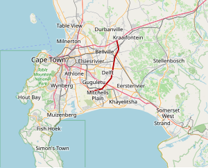
The R300 or Kuils River Freeway (also Cape Flats Freeway) is a Regional Route in the Cape Metropole, South Africa that connects Mitchells Plain with the N2, Kuilsrivier, and the N1 between Bellville and Brackenfell. The R300 is a freeway for its entire length; it forms part of the proposed Peninsula Expressway.
Route
The R300 begins at the Stellenberg Interchange with the N1 between Bellville and Brackenfell and heads south bordering between both towns. It eventually borders between Bellville and Kuilsrivier and borders between Delft and Blue Downs before intersecting with the N2 (Settlers Way) north of Mitchells Plain and Philippi. It then turns in a south-westerly direction between Mitchells Plain and Phillipi and ends at an intersection with the M7 (Jakes Gerwel Drive) in Mitchells Plain.

Interchanges
| Distance from origin (km) | Exit number | Destinations | Roads | Notes |
|---|---|---|---|---|
| 0 | Mitchells Plain | M7- Jakes Gerwel Drive | ||
| 3 | 12 | Mitchells Plain, Philippi | M36- Stock Road | |
| 5 | 22 | Cape Town, Somerset West | N2 | |
| 9 | 18 | Blue Downs | M54- Hindle Road | |
| 12 | 21 | Blackheath | M12- Stellenbosch Arterial | |
| 16 | 25 | Kuilsrivier, Bellville | R102- Van Riebeek Road | |
| 17 | 26 | Kuilsrivier | M23- Bottelary Road | Southbound only |
| 20 | 29 | Brackenfell, Bellville | R101- Old Paarl Road | Northbound only |
| 22 | 27 | Cape Town, Paarl | N1 | R300 ends |
Peninsula Expressway
Main article: N21 (Cape Town)The entirety of the R300 Freeway is part of the proposed Peninsula Expressway, which is to be designated as the N21 and is to be a toll road. This new national route is to include the current R300 freeway as well as extensions at either end of that R300 freeway.
The proposed road is meant to extend the current R300 from its northern terminus (Stellenberg Interchange) with the N1 highway, past Durbanville, bending west, up to the Melkbosstrand and Blouberg coastal area. It is also meant to extend the current R300 from its southern terminus (Mitchells Plain) junction with the M7 route (Jakes Gerwel Drive) westwards, through Zeekoevlei, up to the Muizenberg and Westlake area.
In August 2022 the Western Cape Department of Transport and Public Works announced the launch of an environmental impact assessment for the extension of the R300 from its current terminus at the N1 northwards to the R302 (Wellington Road).
References
- ^ Falkner, John (May 2012). South African Numbered Route Description and Destination Analysis (Report). National Department of Transport. p. 95. Archived from the original on 6 June 2014. Retrieved 2 September 2014.
- "R300 Project | SANRAL". www.nra.co.za/. Retrieved 26 March 2021.
- "Engineering News - Tenders this year for Cape toll ring road". Engineering News. Retrieved 26 March 2021.
- (South Africa Firm), Chand Ecosense JV (2002). The Proposed N21 (R300) Cape Town Ring Road Toll Project: Environmental Impact Assessment. Chand Ecosense JV.
- ^ "Developers quizzed on R300 'promise'". www.iol.co.za. Retrieved 26 March 2021.
- Erasmus, Esmé (17 August 2022). "Plan to extend R300 north of the N1 highway is taking shape". TygerBurger. Retrieved 5 November 2022.
External links
| Numbered routes in the Western Cape | ||
|---|---|---|
| National routes |  | |
| Provincial routes | ||
| Regional routes | ||
This South African road or road transport-related article is a stub. You can help Misplaced Pages by expanding it. |