Misplaced Pages

Red Box, California

Article snapshot taken from[REDACTED] with creative commons attribution-sharealike license. Give it a read and then ask your questions in the chat. We can research this topic together.
Unincorporated community in California, United States

34°15′30.5″N 118°06′18.8″W / 34.258472°N 118.105222°W / 34.258472; -118.105222

Red Box, California is located in the Los Angeles metropolitan areaRed Box, Californiaclass=notpageimage| Location of Red Box within Greater Los Angeles.

Red Box is the name of the junction of the Angeles Crest Highway, the Mt. Wilson-Red Box Road, and the Rincon-Red Box Road. It is located at the 1,422-meter (4,665 ft) saddle between Mount Lawlor and San Gabriel Peak. The saddle separates the upper Arroyo Seco drainage from the West Fork of the San Gabriel River.
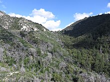
Red Box Saddle viewed from the east in 2019

References

  1. "Hike the Arroyo Second". arroyoseco.org. Retrieved July 10, 2019.
Municipalities and communities of Los Angeles County, California, United States
County seat: Los Angeles
Cities
Los Angeles County map
CDPs
Unincorporated
communities


Stub icon

This Los Angeles County, California–related article is a stub. You can help Misplaced Pages by expanding it.

Categories:
Red Box, California Add topic