| Roca de la Feixa | |
|---|---|
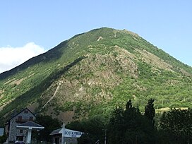
 Roca de la Feixa seen from Barruera Roca de la Feixa seen from Barruera | |
| Highest point | |
| Elevation | 2,093 m (6,867 ft) |
| Listing | Mountains in Catalonia |
| Coordinates | 42°30′12.79″N 0°50′19.47″E / 42.5035528°N 0.8387417°E / 42.5035528; 0.8387417 |
| Geography | |
| Location | Alta Ribagorça, Catalonia |
| Parent range | Pyrenees |
| Climbing | |
| First ascent | Unknown |
| Easiest route | Drive to Durro, Vall de Boí, then hike |
Roca de la Feixa is a massive mountain of the Pyrenees, Catalonia, Spain. It has an elevation of 2,093 metres above sea level.
This mountain's summit rises above Durro village. It is located within the municipal limits of Vall de Boí, Alta Ribagorça.
References
- "Mapa Topogràfic de Catalunya". Institut Cartogràfic de Catalunya. Retrieved May 22, 2010..
This article about a location in Catalonia is a stub. You can help Misplaced Pages by expanding it. |