| Rovensko | |
|---|---|
| Municipality | |
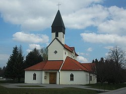
 Local church in Rovensko, Slovakia Local church in Rovensko, Slovakia | |
 Coat of arms Coat of arms | |
  | |
| Coordinates: 48°43′00″N 17°23′00″E / 48.71667°N 17.38333°E / 48.71667; 17.38333 | |
| Country | Slovakia |
| Region | Trnava |
| District | Senica |
| First mentioned | 1439 |
| Government | |
| • Mayor | Ján Ňukovič |
| Area | |
| • Total | 10.4 km (4.0 sq mi) |
| Elevation | 216 m (709 ft) |
| Population | |
| • Total | 393 |
| • Density | 38/km (98/sq mi) |
| Time zone | UTC+1 (CET) |
| • Summer (DST) | UTC+2 (CEST) |
| Postal code | 905 01 (pošta Senica 1) |
| Area code | +421-34 |
| Car plate | SE |
| Municipality code | 504777 |
| Website | www.rovensko.sk |
| www.e-obce.sk | |
Rovensko (Hungarian: Berencsróna, until 1899: Rovenszkó) is a village and municipality administered as part of Senica District in the Trnava Region of western Slovakia. The village is about 5 km NNE of the town of Senica and is close to the border with the Czech Republic.
History
In historical records the village was first mentioned in 1439.
Geography
The municipality lies at an altitude of 216 metres and covers an area of 1,040 hectares. In 2007 the population was 393.
Notes
External links
[REDACTED] Media related to Rovensko at Wikimedia Commons
| Municipalities of Senica District | ||
|---|---|---|
This Trnava Region geography article is a stub. You can help Misplaced Pages by expanding it. |