| São Lourenço do Sul | |
|---|---|
| Municipality | |
 Flag Flag Seal Seal | |
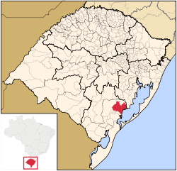
 Location within Rio Grande do Sul Location within Rio Grande do Sul | |
 | |
| Coordinates: 31°22′02.14″S 51°58′46.37″W / 31.3672611°S 51.9795472°W / -31.3672611; -51.9795472 | |
| Country | |
| Region | South |
| State | Rio Grande do Sul |
| Founded | 26 April 1884 |
| Government | |
| • Mayor | Rudinei Harter (PDT); (2017–2020) |
| Area | |
| • Total | 2,036.125 km (786.152 sq mi) |
| Population | |
| • Total | 43,540 |
| • Density | 21/km (55/sq mi) |
| Time zone | UTC−3 (BRT) |
| Postal Code | 96170-000 |
| Website | http://www.saolourencodosul.rs.gov.br/ |
São Lourenço do Sul is a Brazilian municipality in the state of Rio Grande do Sul. The municipality had 43,111 inhabitants in the last Census (2010). Its population in 2020 was estimated in 43,540 inhabitants. It is located at the west bank of the big lagoon Lagoa dos Patos.
The municipality contains part of the 7,993-hectare (19,750-acre) Camaquã State Park, created in 1975.
See also
External links
Government (in Portuguese)
Coordinates
31°22′02.14″S 51°58′46.37″W / 31.3672611°S 51.9795472°W / -31.3672611; -51.9795472
References
- IBGE 2020
- Parque Estadual do Camaquã (in Portuguese), SEMA: Secretaria do Ambiente e Desenvolvimento Sustentável (RS), retrieved 2017-01-22
31°21′55″S 51°58′42″W / 31.36528°S 51.97833°W / -31.36528; -51.97833
 | This geographical article relating to Rio Grande do Sul is a stub. You can help Misplaced Pages by expanding it. |
