| Sandravinany | |
|---|---|
 | |
| Coordinates: 24°2′S 47°26′E / 24.033°S 47.433°E / -24.033; 47.433 | |
| Country | |
| Region | Atsimo-Atsinanana |
| District | Vangaindrano |
| Area | |
| • Total | 380 km (150 sq mi) |
| Elevation | 14 m (46 ft) |
| Population | |
| • Total | 10,000 |
| Time zone | UTC3 (EAT) |
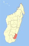
Sandravinany is a rural municipality in Madagascar. It belongs to the district of Vangaindrano, which is a part of Atsimo-Atsinanana Region. The population of the commune was estimated to be approximately 10,000 in 2001 commune census.
Only primary schooling is available. The majority 90% of the population works in fishing. 9% are farmers. The most important crop is cassava, while other important products are sweet potatoes and rice. Services provide employment for 1% of the population.
Situated on the seashore the municipality has beaches over 18km. It produced 47 tons of lobsters in 2017.
References and notes
- Projet de réhabilitation de la RN12A entre Ebakika PK 44+850 et Manambondro PK 165+231
- Estimated based on DEM data from Shuttle Radar Topography Mission
- ^ "ILO census data". Cornell University. 2002. Retrieved 2008-05-05.
- Projet de réhabilitation de la RN12A entre Ebakika PK 44+850 et Manambondro PK 165+231
| Capital: Farafangana | ||
| Befotaka Sud (6) - 307 |  | |
| Farafangana (30) - 309 |
| |
| Midongy-Atsimo (6) - 318 | ||
| Vangaindrano (28) - 320 | ||
| Vondrozo (16) - 322 | ||
| 5 districts; 86 communes | ||
24°2′S 47°26′E / 24.033°S 47.433°E / -24.033; 47.433
This Atsimo-Atsinanana location article is a stub. You can help Misplaced Pages by expanding it. |