| Sela | |
|---|---|
 | |
 | |
| Coordinates: 46°22′14.06″N 15°49′34.14″E / 46.3705722°N 15.8261500°E / 46.3705722; 15.8261500 | |
| Country | |
| Traditional region | Styria |
| Statistical region | Drava |
| Municipality | Videm |
| Area | |
| • Total | 3.04 km (1.17 sq mi) |
| Elevation | 230.5 m (756.2 ft) |
| Population | |
| • Total | 188 |
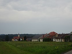
Sela (pronounced [ˈseːla]) is a settlement on the left bank of the Polskava River south of Ptuj in eastern Slovenia. It belongs to the Municipality of Videm and forms a more or less continuous settlement together with Barislovci. The area is part of the traditional region of Styria. It is now included in the Drava Statistical Region.
The local church, built 1904 and dedicated to the Holy Family, although technically in Barislovci, is known locally as the church at Sela. There is also a small chapel-shrine with a belfry at the village crossroads. It was built in 1920.
References
- Statistical Office of the Republic of Slovenia
- Videm municipal site
- "Barislovci - Cerkev sv. Družine". Register kulturne dediščine. Slovenian Ministry of Culture. Retrieved July 27, 2019.
- "Sela na Dravskem polju - Kapelica". Register kulturne dediščine. Slovenian Ministry of Culture. Retrieved July 27, 2019.
External links
This article about the Municipality of Videm in Slovenia is a stub. You can help Misplaced Pages by expanding it. |
