Misplaced Pages

Sephu Gewog

Article snapshot taken from[REDACTED] with creative commons attribution-sharealike license. Give it a read and then ask your questions in the chat. We can research this topic together.
Gewog in Wangdue Phodrang District, Bhutan
Sephu Gewog སྲས་ཕུག་
Gewog
Location of Sephu Gewog
Country Bhutan
DistrictWangdue Phodrang District
Time zoneUTC+6 (BTT)

Sephu Gewog (Dzongkha: སྲས་ཕུག་, also transliterated as Saephoog Gewog is a gewog (village block) of Wangdue Phodrang District, Bhutan.

At an altitude ranging from 2600 to 3500 meters above sea level, Saephoog gewog is situated en route to Trongsa, located north eastern part of Wangduephodrang dzongkhag. One can reach Saephoog gewog centre after three hours’ drive from Wangdue dzongkhag by passing the rough highway road, made due to the stone quarry and road widening along the highway. The gewog comprises five chiwogs (Buso-Zeri, Rukubjee, Longtoed, Bumilog and Nakha) with a total of 331 households, and a population of 1505 people. Saephoog consists of an estimated area of 110801.221758 ha, the largest among the other gewogs under Wangdue. The chiwogs are scattered away from each other but the households under individual chiwogs are nucleated.

Saephoog Gewog enjoys a temperate climate with mostly rugged terrain and snow fall during winter. The Gewog has high potential for livestock and has established one milk processing unit one at Rukubjee. Potato cultivation dominates among the agriculture farming activities and most of the production were sold to Punatshangchu project through farmers group.

During the cordyceps season (June) the villagers used to migrate to the highlands for cordyceps collection leaving behind those who can't afford to walk. The Gewog Administration used to issue three permits per household for the duration of one month. It is one of the main sources of income for Saephoog farmers.

Most of the villages under Saephoog enjoy the basic needs like electricity, rural water supply scheme, farm roads and telecommunication. Total the gewog has connected approximately 45.52 km of farm roads to villages as of now, which made it easier for farmers to transport their products to the nearest market.
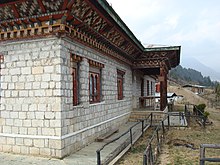
Sephu Basic Health Unit (BHU) and Community Mail Office (CMO)

Government infrastructure such as schools, RNR and a Basic health unit was also established for service delivery. A Community Centre with facilities such as photocopy, half photo and internet was operational in the year 2013 with one operator, and benefits the farmers in terms of time consumption and transportation expenses.

Out of 7 communities and 2 privately owned lhakhang, The WangdueGoenpa lhakhang has a monastic education centre at present.

References

  1. See the Geog profile information provided by the Wangdue Phodrang Dzongkhag Administration.
  2. "Chiwogs in Wangdue Phodrang" (PDF). Election Commission, Government of Bhutan. 2011. Archived from the original (PDF) on 2011-10-02. Retrieved 2011-07-28.
  3. "-". Royal Government of Bhutan. Retrieved December 12, 2010.
Village groups (gewogs) of Bhutan
Central
Bhutan Zone
Dagana District
Dorona
Drujegang
Gesarling
Goshi
Karmaling
Karna
Khebisa
Lajab
Lhamoy Zingkha
Nichula
Tashiding
Tsangkha
Tsendagang
Tseza
Gasa District
Khamaed
Khatoed
Laya
Lunana
Punakha District
Barp
Chhubu
Dzomi
Goenshari
Guma
Kabjisa
Lingmukha
Shenga Bjime
Talog
Toepisa
Towang
Tsirang District
Barshong
Dunglegang
Gosarling
Kilkhorthang
Mendrelgang
Patshaling
Phuentenchhu
Rangthangling
Semjong
Sergithang
Tsholingkhar
Tsirangtoe
Wangdue Phodrang District
Athang
Bjendag
Dangchu
Darkar
Gangteng
Gasetsho Gom
Gasetsho Om
Kazhi
Nahi
Nyisho
Phangyuel
Phobji
Ruepisa
Sephu
Thedtsho
Bhutan
Southern
Bhutan Zone
Bumthang District
Chhume
Choekor
Tang
Ura
Sarpang District
Chhuzagang
Chhudzom
Dekiling
Gakiling
Gelephu
Jigmechhoeling
Samtenling
Senghe
Serzhong
Shompangkha
Tareythang
Umling
Trongsa District
Dragteng
Korphu
Langthil
Nubi
Tangsibji
Zhemgang District
Bardo
Bjoka
Goshing
Nangkor
Ngangla
Phangkhar
Shingkhar
Trong
Western
Bhutan Zone
Chukha District
Bjacho
Bongo
Chapcha
Dala
Dungna
Geling
Getena
Logchina
Metakha
Phuentsholing
Sampheling
Haa District
Bji
Gakiling
Katsho
Sama
Sangbay
Uesu
Paro District
Dokar
Dopshari
Doteng
Hungrel
Lamgong
Lungnyi
Naja
Shapa
Tsento
Wangchang
Samtse District
Dungtoe
Dophoogchen
Denchukha
Namgaychhoeling
Norbugang
Norgaygang
Pemaling
Phuentshogpelri
Samtse
Sangngagchhoeling
Tading
Tashicholing
Tendu
Ugentse
Yoeseltse
Thimphu District
Chang
Darkarla
Genye
Kawang
Lingzhi
Mewang
Naro
Soe
Eastern
Bhutan Zone
Lhuntse District
Gangzur
Jaray
Khoma
Kurtoe
Menbi
Metsho
Minjay
Tsenkhar
Mongar District
Balam
Chaskhar
Chhali
Drametse
Drepung
Gongdue
Jurmey
Kengkhar
Mongar
Narang
Ngatshang
Saling
Shermuhoong
Silambi
Thangrong
Tsakaling
Tsamang
Pemagatshel District
Chimoong
Choekhorling
Chongshing
Dechenling
Dungmaed
Khar
Nanong
Norbugang
Shumar
Yurung
Zobel
Samdrup Jongkhar District
Dewathang
Gomdar
Langchenphu
Lauri
Martshala
Orong
Pemathang
Phuntshothang
Samrang
Serthi
Wangphu
Trashigang District
Bartsham
Bidung
Kanglung
Kangpar
Khaling
Lumang
Merag
Phongmed
Radi
Sakteng
Samkhar
Shongphoog
Thrimshing
Uzorong
Yangnyer
Trashiyangtse District
Bumdeling
Jamkhar
Khamdang
Ramjar
Toetsho
Tomzhangsa
Yangtse
Yalang
Former Gewogs
Dagana District
Deorali
Chukha District
Bhulajhora
Pemagatshel District
Nganglam
Samtse District
Chargharey
Chengmari
Ghumauney
Mayona
Nainital
Pagli
Sarpang District
Bhur
Doban
Hilley
Taklai
Thimphu District
Bapbi
Tsirang District
Beteni
Chanautey
Gairigaun
Tshokhana
Tsirang Dangra
Samdrup Jongkhar District
Bakuli
Hastinapur


Stub icon

This Bhutan location article is a stub. You can help Misplaced Pages by expanding it.

Categories:
Sephu Gewog Add topic