Village in Uttar Pradesh, India
| Singhpur | |
|---|---|
| Village | |
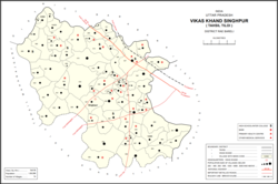
 Map of Singhpur CD block Map of Singhpur CD block | |
 | |
| Coordinates: 26°28′55″N 81°26′31″E / 26.481904°N 81.441914°E / 26.481904; 81.441914 | |
| Country India | |
| State | Uttar Pradesh |
| District | Raebareli |
| Area | |
| • Total | 6.116 km (2.361 sq mi) |
| Population | |
| • Total | 2,826 |
| • Density | 460/km (1,200/sq mi) |
| Languages | |
| • Official | Hindi |
| Time zone | UTC+5:30 (IST) |
| PIN | 229308 |
| Vehicle registration | UP-35 |
Singhpur is a village and corresponding community development block in Tiloi tehsil of Rae Bareli district, Uttar Pradesh, India. As of 2011, its population is 2,826, in 549 households. It is located 16 km from Tiloi, the tehsil headquarters, and 20 km from the town of Maharajganj. The main staple foods are wheat and rice.
The 1961 census recorded Singhpur as comprising 11 hamlets, with a total population of 1,179 people (617 male and 562 female), in 303 households and 296 physical houses. The area of the village was given as 998 acres.
The 1981 census recorded Singhpur as having a population of 1,418 people, in 317 households, and having an area of 396.60 hectares.
Villages
Singhpur CD block has the following 74 villages:
| Village name | Total land area (hectares) | Population (in 2011) |
|---|---|---|
| Kharawa | 213.6 | 2,590 |
| Sighhawapur | 25.4 | 298 |
| Kusumbhi | 171.4 | 961 |
| Tikari | 512.3 | 2,282 |
| Kukaha Rampur | 576.8 | 3,711 |
| Mahiya Senduriya | 753.5 | 4,557 |
| Goyan | 160.5 | 1,050 |
| Nagiya Mou | 146.2 | 805 |
| Hathrohana | 197.1 | 1,612 |
| Lauli | 481.5 | 2,864 |
| Sakatpur | 107.8 | 551 |
| Jaitpur | 248.4 | 2,164 |
| Tedhai | 281 | 1,967 |
| Jagatpur | 177.1 | 1,582 |
| Raja Patti | 52.8 | 457 |
| Mahimanpur | 17 | 3,059 |
| Sultanpur Bahengi | 47 | 550 |
| Naukhera | 283.8 | 1,668 |
| Dubeypur | 39.2 | 399 |
| Anguri | 184.3 | 1,373 |
| Ashrafpur | 126 | 1,037 |
| Chilauli | 213.3 | 2,616 |
| Kotwa | 570.3 | 4,832 |
| Satan Purwa | 716.8 | 7,719 |
| Bhanipur | 228.1 | 1,574 |
| Gadhi Mahabal | 127.5 | 1,575 |
| Ahorwa Bhwani | 103.3 | 1,477 |
| Khara | 1,158.2 | 7,320 |
| Jehta Usarha | 276.3 | 2,923 |
| Kharagpur | 217.7 | 1,512 |
| Perariya | 300.4 | 1,527 |
| Perara | 549 | 3,651 |
| Khekharuwa | 350 | 2,320 |
| Rampur Panwara | 387 | 2,128 |
| Ratwaliya Manjhar | 553.9 | 2,289 |
| Singhpur (block headquarters) | 611.6 | 2,826 |
| Panhauna | 890.7 | 7,075 |
| Patti Bakshi | 36.8 | 522 |
| Bhawanipur | 78.6 | 1,328 |
| Gopalpur | 39.7 | 469 |
| Dhirapur | 186.4 | 1,256 |
| Ramganj | 155.4 | 1,129 |
| Jainagara | 222 | 1,850 |
| Saraiya Salarpur | 250.9 | 914 |
| Dangi Barwaliya | 92 | 1,491 |
| Inhauna | 862 | 13,049 |
| Sarai Madho | 259 | 1,212 |
| Sadhiya | 277 | 2,230 |
| Azadpur | 565.2 | 6,373 |
| Mahmood Sarai | 31.6 | 248 |
| Miyan Ganj | 74.9 | 670 |
| Ahmadabad Pipari | 307 | 2,808 |
| Jijauli | 303.6 | 1,664 |
| Jiyapur | 834.6 | 1,434 |
| Otiya | 102.8 | 1,857 |
| Shekhan Gaon | 1,028 | 2,615 |
| Fatehpur | 368.8 | 5,348 |
| Rajapur | 346 | 3,954 |
| Bhikhipur | 246.1 | 2,900 |
| Godhana | 195.4 | 993 |
| Dandupur | 473 | 2,726 |
| Jugrajpur | 374 | 3,896 |
| Phoola | 1,359.7 | 7,726 |
| Rampur | 91.3 | 543 |
| Hasanpur | 121.5 | 1,162 |
| Konchi | 264.3 | 1,914 |
| Rasta Mau | 697.1 | 7,859 |
| Chilauli | 529.3 | 3,429 |
| Karan Gaon | 470.7 | 3,500 |
| Bahua | 433.3 | 5,645 |
| Mirzagarh | 258.5 | 2,596 |
| Khanapur Chapara | 491.3 | 4,738 |
| Mattepur | 244.9 | 2,682 |
| Usufnagar | 293 | 2,625 |
References
- "GeoNames Search". geonames.nga.mil. Archived from the original on 12 April 2014. Retrieved 27 June 2023.
- ^ "Census of India 2011: Uttar Pradesh District Census Handbook - Rae Bareli, Part A (Village and Town Directory)" (PDF). Census 2011 India. pp. 125–41. Retrieved 28 July 2021.
- ^ Census 1961: District Census Handbook, Uttar Pradesh (39 - Raebareli District) (PDF). Lucknow. 1965. pp. 149, xx-xxi of section "Maharajganj Tahsil". Retrieved 28 July 2021.
{{cite book}}: CS1 maint: location missing publisher (link) - ^ Census 1981 Uttar Pradesh: District Census Handbook Part XIII-A: Village & Town Directory, District Rae Bareli (PDF). 1982. pp. 48–9. Retrieved 28 July 2021.
This Raebareli district location article is a stub. You can help Misplaced Pages by expanding it. |