| This article does not cite any sources. Please help improve this article by adding citations to reliable sources. Unsourced material may be challenged and removed. Find sources: "Siteki" – news · newspapers · books · scholar · JSTOR (December 2009) (Learn how and when to remove this message) |
| Siteki | |
|---|---|
 | |
| Coordinates: 26°27′S 31°57′E / 26.450°S 31.950°E / -26.450; 31.950 | |
| Country | |
| District | Lubombo |
| Elevation | 619 m (2,031 ft) |
| Population | |
| • Total | 6,381 |
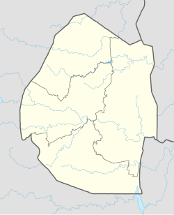
Siteki is a town in eastern Eswatini, lying west of the Lebombo Mountains, with an estimated population of 6,381 as of 2013. It is named for a declaration of Mbandzeni permitting his troops to marry. The town name was listed as Stegi in the 1966 census, and the population then was 1,457. The 1956 census counted 612 residents in Stegi.
It is also a place very dense populated in areas well known like Mzilikazi, along the road to town. It has two royal homes. Before Mzilikazi there is a Queen's home and then another one at Emoyen for the King.
Siteki is also a town that comprises different kinds of nations. As we know there is a refugee camp situated at Mpaka, thus for making a lot of mixed people trading around the town.
26°27′S 31°57′E / 26.450°S 31.950°E / -26.450; 31.950
This Eswatini location article is a stub. You can help Misplaced Pages by expanding it. |