Human settlement in England
| Skipsea | |
|---|---|
 | |
| Population | 693 (2011 census) |
| OS grid reference | TA168550 |
| Civil parish |
|
| Unitary authority | |
| Ceremonial county | |
| Region | |
| Country | England |
| Sovereign state | United Kingdom |
| Post town | DRIFFIELD |
| Postcode district | YO25 |
| Dialling code | 01262 |
| Police | Humberside |
| Fire | Humberside |
| Ambulance | Yorkshire |
| UK Parliament | |
| 53°58′40″N 0°13′12″W / 53.97778°N 0.22000°W / 53.97778; -0.22000 | |
Skipsea is a village and civil parish on the North Sea coast of the East Riding of Yorkshire, England. It is situated approximately 10 miles (16 km) south of Bridlington and 6 miles (9.7 km) north of Hornsea on the B1242 road at its junction with the B1249 road.
The civil parish is formed by the village of Skipsea and the hamlets of Skipsea Brough and Dringhoe. According to the 2011 UK census, Skipsea parish had a population of 693, an increase on the 2001 UK census figure of 633.
From the mediaeval era until the 19th century Skipsea was part of Dickering Wapentake. Between 1894 and 1974 Skipsea was a part of the Bridlington Rural District, in the East Riding of Yorkshire. Between 1974 and 1996 it was part of the Borough of North Wolds (later Borough of East Yorkshire), in the county of Humberside.
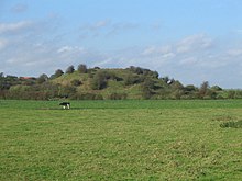
Just to the west of the village, in Skipsea Brough, lies Skipsea Castle. Built in 1086, the motte-and-bailey style castle has since been destroyed; however impressive earthworks remain. The coast near Skipsea, just over 0.6 miles (1 km) to the east, is the fastest eroding coastline in northern Europe.
History

The first recorded appearance of the name Skipsea is in the 12th century and the name is of Scandinavian origin, but the actual town-site has been in use much longer. This is of no real surprise, as this part of the English coast was frequented by Viking invaders before the Norman Conquest. There is some evidence that the name Skipsea refers to its original Viking meaning of "Ship Lake", but the closest literal meaning of Skipsea is "a lake navigable by ships". This name refers to the village's original location on the edge of a lake, which was suitable for navigation and eel-fishing, that was slightly inland from the sea. This land has since been lost because of erosion, making Skipsea a seaside Village. There is evidence of habitation dating back to the Stone and Bronze Ages because of the 19th century archaeological discovery of platforms, presumably for huts.
The borough of Skipsea Castle was first recorded between 1160 and 1175 and may have been founded by William le Gros, Count of Aumale, who died in 1179.
By the end of the 11th century, both Skipsea Castle and a church had been built, which encouraged the growth of a small town. In the following 13th and 14th centuries, local markets and fairs were granted "variously for Skipsea town, Skipsea manor, and Skipsea Brough manor, presumably all the same and possibly by then meaning Skipsea village".
The parish Church of All Saints was designated a Grade I listed building in 1966 and is now recorded in the National Heritage List for England, maintained by Historic England.
The village is also famous for being a possible site for nuclear testing in the 1950s, yet the scientists at Aldermaston relented after strong opposition by the local community.
The Royal Observer Corps used Skipsea as a site for a Cold War observation post. The site was active from October 1959 until its decommissioning in September 1991. The site lay derelict until it was restored by an enthusiast in October 2008.
Currently, the economy of Skipsea is based on agriculture and tourism.
References
- ^ UK Census (2011). "Local Area Report – Skipsea Parish (1170211259)". Nomis. Office for National Statistics. Retrieved 24 February 2018.
- UK Census (2001). "Local Area Report – Skipsea Parish (00FB130)". Nomis. Office for National Statistics. Retrieved 25 February 2020.
- "Dickering-Wap through time". A Vision of Britain Through Time. University of Portsmouth. Retrieved 24 November 2019.
- "Bridlington RD". A Vision of Britain Through Time. University of Portsmouth. Archived from the original on 10 February 2012. Retrieved 11 April 2013.
- Halliday, Josh (18 January 2020). "'It's a monster': the Skipsea homes falling into the North Sea". The Guardian. Retrieved 18 January 2020.
- ^ "Victoria County History: A History of the County of York East Riding: Volume 7: Holderness Wapentake, Middle and North Divisions: 'North division: Skipsea'". British History Online. 2002. Retrieved 6 February 2008.
- ^ "Skipsea Castle". Archived from the original on 10 September 2004. Retrieved 7 February 2013.
- Historic England. "Church of All Saints (1083824)". National Heritage List for England. Retrieved 11 August 2013.
- "QI + DND = UK". Best Western. 26 May 2011. Archived from the original on 13 June 2011. Retrieved 7 February 2013.
- "Skipsea Tourist Information". Retrieved 7 February 2013.
- Newton, Grace (23 April 2018). "The Yorkshire village that nearly became a nuclear bomb testing site". The Yorkshire Post. Retrieved 14 March 2019.
- Gazetteer — A–Z of Towns Villages and Hamlets. East Riding of Yorkshire Council. 2006. p. 10.
| Yorkshire Portal | |
| Statutory City Region | Hull and East Yorkshire Combined Authority |
| Unitary authorities | |
| Major settlements (cities in italics) | |
| Rivers | |
| Canals | |
| Topics | |
| Populated coastal places in the East Riding of Yorkshire | ||||
|---|---|---|---|---|
| ||||