| This article does not cite any sources. Please help improve this article by adding citations to reliable sources. Unsourced material may be challenged and removed. Find sources: "Suranarai Road" – news · newspapers · books · scholar · JSTOR (December 2015) (Learn how and when to remove this message) |
 National Highway 205
 | |
|---|---|
| ทางหลวงแผ่นดินหมายเลข 205 | |
| Major junctions | |
| From | Lopburi |
| To | Tambon Nai Muaeng |
| Location | |
| Country | Thailand |
| Major cities | Nakhon Ratchasima |
| Highway system | |

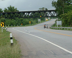
Suranarai Road (Thai: ถนนสุรนารายณ์) or Thailand Route 205 is a road connecting Lopburi Province with northeastern Thailand. The road begins at Ban Mi District, Lopburi Province and ends at Mueang Nakhon Ratchasima District, Nakhon Ratchasima Province. It is a strategic inter-regional road, linking the Lopburi military base in central Thailand to Nakhon Ratchasima. The road was built in 1943, during Prime Minister Field marshal Plaek Phibunsongkhram's tenure, but was not completed until 1951. Part of the road was built on abandoned railway track, with several railway bridges being converted into road bridges.
The districts and provinces along the road are Amphoe Khok Samrong, Amphoe Chai Badan, and Amphoe Lam Sonthi of Lopburi Province, Amphoe Thep Sathit and Amphoe Bamnet Narong of Chaiyaphum Province, and Amphoe Phra Thong Kham and Amphoe Non Thai of Nakhon Ratchasima Province.
| Lopburi Province | ||
|---|---|---|
| Lopburi (capital) | ||
| Districts (amphoe) |  | |
| Royalty | ||
| Related topics | ||
| Neighboring areas | ||
This Thailand location article is a stub. You can help Misplaced Pages by expanding it. |
This Thailand road article is a stub. You can help Misplaced Pages by expanding it. |