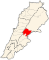
| Taalabaya تعلبايا | |
|---|---|
| Village | |
 | |
| Coordinates: 33°49′01″N 35°52′00″E / 33.81694°N 35.86667°E / 33.81694; 35.86667 | |
| Country | |
| Governorate | Beqaa Governorate |
| District | Zahlé |
| Elevation | 2,990 ft (910 m) |
| Time zone | UTC+2 (EET) |
| • Summer (DST) | +3 |
Taalabaya (Arabic: تعلبايا), is a village located in the Zahlé District of the Beqaa Governorate in Lebanon.
History
In 1838, Eli Smith noted Tha'labaya as a Beqaa Valley village inhabited by Sunni Muslims, Maronites and Christians.
In December of 1975, the town of Taalabaya was attacked by PLA insurgents during the Lebanese Civil War; 35 residents were killed.
References
- Robinson and Smith, 1841, vol 3, 2nd appendix, p. 142
- "Lebanon's Legacy of Political Violence" (PDF). International Center for Transitional Justice. 2013. p. 28. Retrieved 2023-07-14.
Bibliography
- Robinson, E.; Smith, E. (1841). Biblical Researches in Palestine, Mount Sinai and Arabia Petraea: A Journal of Travels in the year 1838. Vol. 3. Boston: Crocker & Brewster.
External links
- Taalabaya, localiban
| Capital: Zahlé | ||
| Towns and villages |  | |
| Other | ||
This Lebanon location article is a stub. You can help Misplaced Pages by expanding it. |