| Tai Sheung Tok, Hong Kong | |
|---|---|
| 大上托 | |
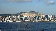
 View of Tai Sheung Tok View of Tai Sheung Tok | |
| Highest point | |
| Elevation | 399 m (1,309 ft) |
| Coordinates | 22°19′30.74″N 114°14′18.18″E / 22.3252056°N 114.2383833°E / 22.3252056; 114.2383833 |
| Geography | |
 | |
| Location | |
Tai Sheung Tok (Chinese: 大上托) is a hill between the communities of Sau Mau Ping and Tseng Lan Shue, Hong Kong.

Geography
Tai Sheung Tok used to be 419m (1,375ft) in height, but because of mining activities by K. Wah Group (owned by Lui Che-woo who went on to become Macau gambling mogul) at the Anderson Quarry in the 20th century, its height has been reduced to 399m (1,309ft).
Civic construction work on the Development at Anderson Road (DAR) is being finished, while another project called the Development of Anderson Road Quarry Site (ARQ) has recently commenced at the foot of Tai Sheung Tok.
Access
Section 3 of the Wilson Trail runs along the north eastern side of Tai Sheung Tok, connecting Ma Yau Tong with Tseng Lan Shue.
See also
References
- Ovalles, Cesar; Rechsteiner, Carl E. Jr. (2015-04-02). Analytical Methods in Petroleum Upstream Applications. CRC Press. ISBN 9781138001480.
- "Major Projects - Development at Anderson Road". www.cedd.gov.hk. Retrieved 2019-09-09.
- "Planning Study on Future Land Use at Anderson Road Quarry - Feasibility Study". www.pland.gov.hk. Retrieved 2019-09-09.
- "Development of Anderson Road Quarry Site - About Development of Anderson Road Quarry Site". arqs.hk. Retrieved 2019-09-09.
External links
| Urban areas of Hong Kong, Kowloon and New Territories | |||||||||||
|---|---|---|---|---|---|---|---|---|---|---|---|
| Hong Kong |
|  | |||||||||
| Kowloon |
| ||||||||||
| New Kowloon |
| ||||||||||
| New Territories |
| ||||||||||
| Official place names are summarized from "Geoinfo Map" of Government of Hong Kong Special Administrative Region, "Hong Kong Guide" of Lands Department, "Hong Kong Guide Book" of Universal Publications Ltd. and "Areas and Districts" of Rating and Valuation Department. M:Narrow meaning of urban areas KL: Kowloon Peninsula at the south of Boundary Street NKL: Former New Territories area at the north of Boundary Street and at the south of Lion Rock 1: Common definition (1) 2: Common definition (2) 3: Common definition (3) 4: Areas not adopting small house concessionary right of indigenous inhabitants 5: Jurisdiction area of former Urban Council 6: Definition of "Metropolitan Area" of Planning Department 7: Jurisdiction area of Urban Renewal Authority 8: Unique operating area of urban taxis 9: "Urban" (9a) and "Extended Urban" (9b) areas defined by Hong Kong Housing Authority 10: Definition of Urban rates 11: Hospital cluster belongs to Hong Kong or Kowloon 12: Police region belongs to Hong Kong or Kowloon 13: Regions having 999-year land lease 14: Geographical Constituency in Hong Kong Legislative Council belongs to Hong Kong or Kowloon 15: Regional Education Office belongs to Hong Kong or Kowloon 16: Primary One Admission School Net belongs to Hong Kong or Kowloon | |||||||||||